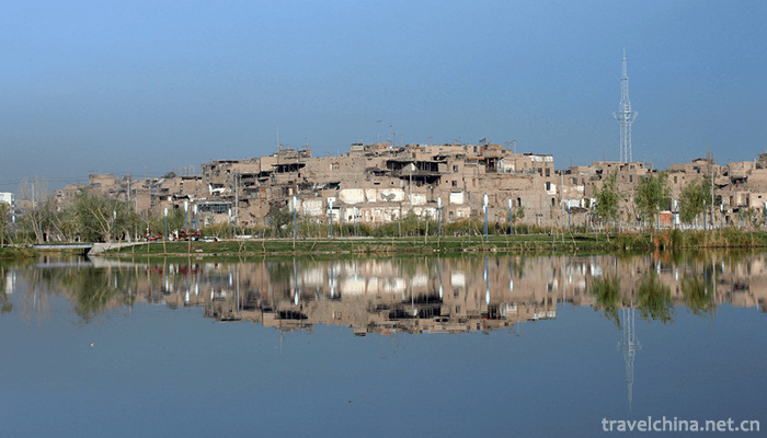
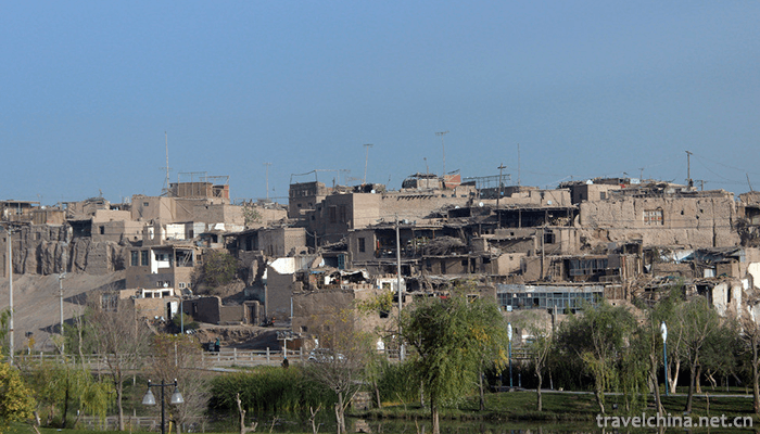
The ancient city of Kashgar, a national AAAAA tourist attraction, covers an area of 20 square kilometers. The capital of Shule was renamed Panzhi City, the predecessor of Shule City in the Western Han Dynasty. According to the textual research in recent years, Pangu Site is the ancient city of Eskesa in the southeast suburb of Kashgar City. It is located on the high port of the junction of the Kizil River and the Turman River. Geographically, this speculation is very likely, but it needs further confirmation, Shule State... Wang Zhishule City. It is the earliest written record of Zhang Qian's ancient city of Kashgar more than 2100 years ago. The formation of Shule (today's Kashgar) will undoubtedly be one or two hundred years ahead of schedule. As for the orientation area of the city, there is no reference at present.
Main attractions
Molstupa
Located on a sand dune in the middle section of the Gumatag Mountains, more than 20 kilometers east suburb of Kashgar, it is separated from the ancient river course of the Chukmak River to the south by the ancient city of Hanoi a few kilometers away. This is a famous Buddhist Temple site near the capital of ancient Shule in the Western Regions of China. It is a building in the middle and late Tang Dynasty. In 2001, Molfo Pagoda was designated as a national cultural relic protection unit.
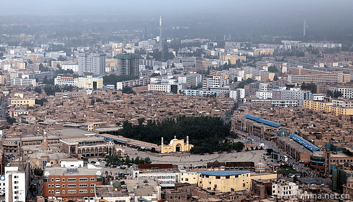
Id Kah Mosque
Founded in 1442, it is situated on the west side of the Etigal Square in the center of the scenic area. It covers an area of 16,820 square meters and covers an area of 25.22 mu. It is one of the largest mosques in Central Asia and is now a key national cultural relic protection unit.
Xiang Fei's hometown
Apahoga Tomb, located in Haohan Village, 5 kilometers northeast of Kashgar City, covers an area of 30 mu. It was built around 1640 A.D. and has been 350 years since. It is a typical Uygur-style ancient mausoleum building. It is now a state-level key cultural relic protection unit.
Ligulu City
In the ancient city of Eskza, the Uygur language of "Eskza" means "broken city". Located on the east side of Paynaf Road in Kashgar City, in 1954, archaeologist Wu Bolun visited the city. From various signs, the Castle of Essex was 17 years from 74 to 91 A.D., and Banchao had been stationed in Shule Guopan Cheng City. It is now a key cultural relic protection unit at the autonomous region level and a patriotic education base in Kashgar.
Fule Wisdom Park
The Tomb of Yusufu Has Hajifu, located in the southern suburb of Kashgar, covers 965 square meters. It was rebuilt in 1987 and reopened in 1988. It is now a key cultural relic protection unit at the autonomous region level.
Lai Ning City
In 1759, the twenty-fourth year of Qianlong reign, the Qing army put down the "Great and Small Huojia Rebellion" and unified the whole of Xinjiang. Shortly afterwards, Yonggui, the minister stationed in Kashgar, wrote a letter to the court asking for a new city to be built as the official office of the court stationed in Kashgar. Qianlong Quartet. Construction began in April 1762 and the new town was completed by the end of August. In 1771, the emperor Qianlong wrote a personal letter for the new city, which was named "Leining City", in order to appease all ethnic groups and people in the border areas to live and work in peace and contentment. Since the liberation of Xinjiang, Leining City has been the place where the public security and armed police are stationed. It is the base of patriotic education in Kashgar.
The Hathpace Folk House
Uygur is originally called "Kuoziqi Abesi Lane", which means "earthenware on high cliffs". Therefore, there are many earthen pottery workshops, so we can get the title. Gaotai houses now have more than 640 households and more than 4000 inhabitants, all of whom are Uygurs. Gaotai covers an area of 86 Mu and has more than 40 lanes, of which 16 are dead ends.
Upal Neolithic Cultural Site
In 1972, four Neolithic cultural sites, Aktala, Wingulok, Kuruktala and Dvorak, were discovered successively in the area of Upal, more than 50 kilometers southwest of Kashgar City. They are universally known as "Upal Neolithic Cultural Site". It is the most Western Neolithic cultural site found so far in China, which indicates that there was a certain origin between primitive human beings on Kashgar oasis and the Yellow River basin in China six or seven thousand years ago.
Ancient City Site of Hanoi
Located 28 kilometers northeast of Kashgar City, located in the territory of Bershkranmu Township, it is an ancient cultural site with the earliest origin and longest development history near Kashgar City. It began in the late Neolithic Age of primitive society (about 4000 years ago) and flourished in the Tang and Song Dynasties (7th to 13th centuries A.D.) until the mid-Qing Dynasty. April 1957 was designated as the key cultural relics protection unit of the autonomous region.
Three fairy cave
Sanxian Cave is located in the north of Kashgar City, more than 10 kilometers north of the right bank of the Bershkranmu River, half of the waist of the cliff. According to time, the earliest excavation of murals and statues in Sanxian Cave in Kashgar was in the middle and late of the 20th century, and its lower limit could reach the period of Wei, Jin, Southern and Northern Dynasties.
Yunmu Laksha Palace
Originally the Yunmulaka Xia Waterlogging Dam, it was the water source of the garrison command in the Qing Dynasty. In the late Qing Dynasty, the military command headquarters had been built on the original site by the citizens. It was once the largest waterlogging dam in the old city of Kashgar. It provided water demand for the surrounding residents for a long time, which was the witness of the residents'life in the ancient city of Kashgar for thousands of years.
Russian Consulate
Around 1890, Tsarist Russia had fully established its foothold in Kashgar. In the spring of 1893, a formal consulate was built at Seman Village in the west of the city, which is today's Seman Hotel. The new consulate covers an area of 15,000 square meters, 22.5 mu. All the houses are built in Russian style. All the bungalows are covered with thick tin vaults, the roofs are painted with dark green paint, and there are large air vents. The interior floor of the house is paved with thick wooden boards, the walls are solid and the walls are glass windows. In winter, the consulate is made of tall thatched furnaces covered with copper skin, and the shape of the consulate is unique and luxurious. Style. Its architectural style has a great influence on the neighborhood architecture after Kashgar. Following this example, Russian architecture is very striking on the streets of Kashgar in the 1940s and 1950s.
british consulate
On August 25, 1908, the British Consulate General in Kashgar was formally established. The first British Consul General in Kashgar was Shu Dehua. At that time, the consulate's office was located in the area of Auto Parts Companies in the region and rented houses. Four years later, in 1912, Britain built a regular consulate in its Niwak Hotel. In order to surpass Russia, it covers an area of 50 mu, more than twice that of the Russian Consulate. The British consulate was designed by Friendberg of the Swedish Missionary Mission in Kazakhstan. It was constructed for five years before and after it was completed by the end of 1917.
Swedish Christian Agency
Located in the site of today's armed forces ministry, covering an area of about 40 mu, there are built-in churches and two Swedish-style bungalows. The church was destroyed in the Kashgar war in 1934. The two bungalows are still preserved with brick structure.
Geng Gong Shrine
Zuo Zongtang led the army into Xinjiang, and Liu Jintang, the commander-in-chief of the front line, drove the Agubai invading army out of Xinjiang and set up a large battalion in Kashgar. He presided over the construction of a magnificent Geng Gong Temple at the top of the old city of Kashgar, under which is "Jiulongquan".
Uygur "spring edge", located in the northeastern part of the scenic spot of a spring, because there are nine spring eyes, the Han people call it "Jiulongquan". From the Qing Dynasty to the early liberation period, Jiulongquan was also called Geng Gong Quan, and an old Buddhist temple in Quanbian was also called Geng Gong Temple, which was a place name attached to the commemoration of Geng Gong, a famous general of the Eastern Han Dynasty.
geographical environment
Located in the center of Kashgar City, Xinjiang Uygur Autonomous Region, south to Renmin Road, north to Seman Road, Yawag Road, West to Yunmu Laksha Road, east to Tuman River sightseeing belt. The ancient city of Kashgar has a long history, rich culture and unique customs. It is known as "not to travel to Kashgar is not counted as Xinjiang, not to travel to the ancient city is not counted as Kashgar".
Traffic information
Kashgar is a transportation hub in southern Xinjiang. Airplanes, trains and buses can reach Kashgar. Kashgar Airport is the second largest airport in Xinjiang, located in the northern suburbs of Kashgar City, about 9 kilometers away from the city center, and has nearly 20 flights to and from Kashgar every day; Kashgar Railway trains have four trips to and from Urumqi every day; Kashgar Highway has eight links, from Urumqi, Hetian, Kashgar, Aksu, Kurla, Turpan and 11 counties in the whole district can take buses.
Within the city, take buses No. 2, No. 7, No. 8, No. 22 and No. 28 to get off at Atticel Station. Seven of them pass through the old city, and you can choose to get off at any station deep in the old city.
0 Questions
Ask a Question
Your email address will not be published.