2019-02-13
- By ChinaWiki.net
- Chinese Edition
- 2018-12-07
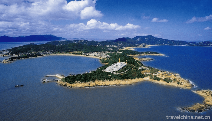
Putuo Mountain Scenic Spot, located about 100 nautical miles east of Hangzhou Bay, Zhejiang Province, is an island in Zhoushan Islands. The island covers an area of 12.5 square kilometers and is long and narrow. The longest point in the north and south is 8.6 miles, and the widest area in the East and West is 3.5 kilometers.
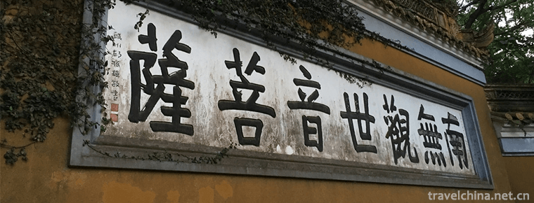
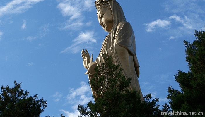
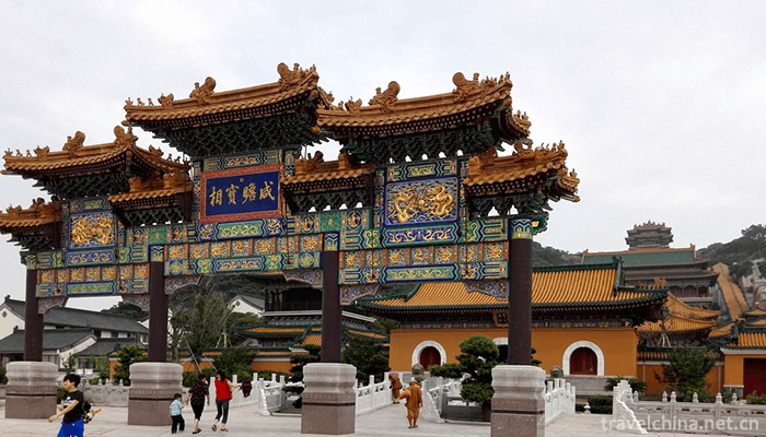
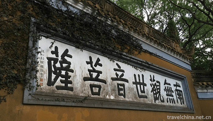
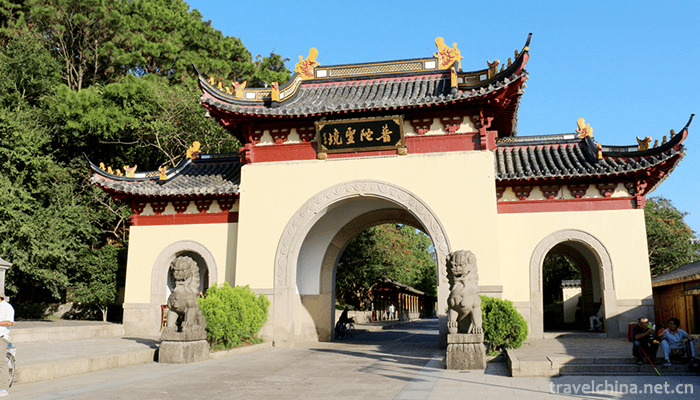
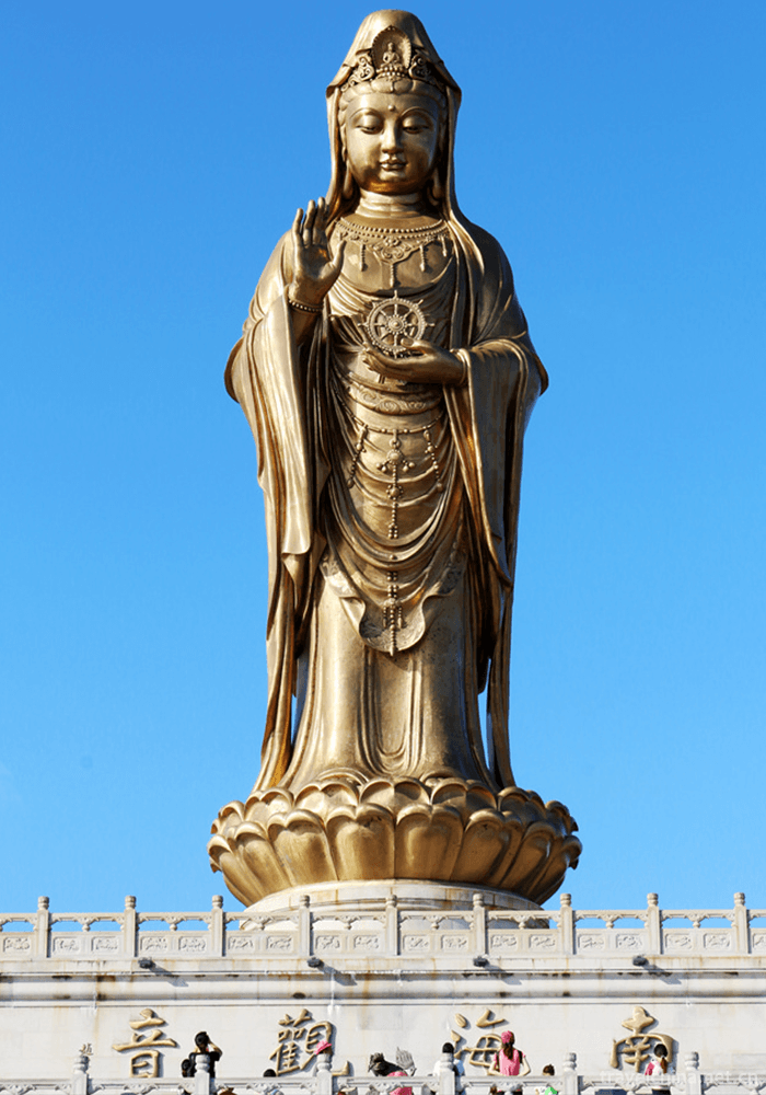
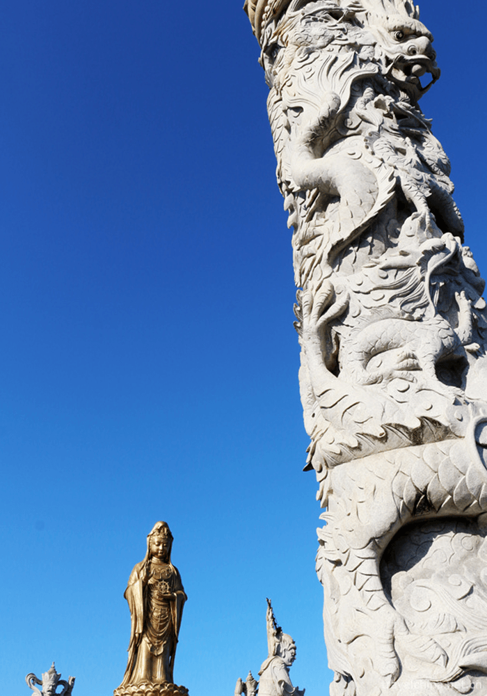
Putuo Mountain Scenic Spot, known as Haitian Buddha Kingdom and Nanhai Holy Land, is the first batch of national key scenic spots. The highest point is Foding Mountain, about 300 meters above sea level. East to Japan, north to Denglai, south to Oumin, West to Wuhui, is the east gate of China. In the second year of Liang Zhenming (916 A.D.) after the Five Dynasties, Hui E, a Japanese monk, invited Guanyin Images to return home from Mount Wutai. He was blocked by the gale through Mount Putuo and stayed in Mao Jiemao in Zizhulin Forest. He refused to go to the Guanyin Academy. Successive dynasties have built monasteries here, mainly for the worship of Guanyin Bodhisattva. Putuo Mountain has also become one of the four major Buddhist temples in China.
Putuo Mountain, formerly known as Mt. Meiqin, was named after Mt. Meifu's monastery in the late Western Han Dynasty. In the fourth year of Tang Xiantong (863), Hui E, a Japanese monk, invited the goddess of Guanyin to return home from Wutai Mountain. He traveled through Lotus Ocean to meet the wind and waves. He thought that if Guanyin refused to go to Japan, he left the goddess and said that he refused to go to Guanyin. In the second year of Zhenming (916), Liang Dynasty of the Five Dynasties refused to go to Guanyin Academy. In the third year of Song and Yuan Dynasties (1080), the court gave silver and rebuilt it into the Guanyin Temple of Baotuo, which has been flourishing ever since. In the seventh year of Jiading in Southern Song Dynasty (1214), it was designated as the Guanyin Daoist Hall. According to Buddhist sutras, it was renamed Ptologa Mountain, also known as Ptologa Mountain. In the Ming Dynasty, a small island in the south of the Lotus Blossom was called Mount Luoga, and there were two mountain names, Mount Putuo and Mount Luoga. Guanyin is called Guanyin in the South China Sea in ancient Tianzhu. It is legendary because: first, Guanyin came out in ancient Tianzhu (now India), while ancient Tianzhu belongs to South Asia, together with Buluojia Mountain, where Guanyin is located, it is called Guanyin in the South China Sea; second, there is no similarity between South China Sea and South China Sea. The famous Tang Dynasty writer Wang Bo's "Guanyin Dashizan" said: "The South China Sea is a deep and secluded place. It's called Qibao Luojia Mountain, where Guanyin lives freely." Wang Bo died in 676. Even though Zan was written in 676, it was 187 years earlier than the refusal to go to Mount Putuo. Obviously, it is not because of Putuo Mountain in the South China Sea that it is called Guanyin in the South China Sea. On the contrary, it is because of Guanyin in the South China Sea that Putuo Mountain is renamed Putuo Mountain in the South China Sea.
Development and construction
In 1982, it was appraised as a national key scenic spot.
In 2007, it was rated as the 5A national tourist attraction in China.
In 2004, it was appraised as the only ISO14000 national demonstration area in Zhejiang Province.
Location territory
Putuo Mountain Scenic Spot is located in the southern margin of Hangzhou Bay and the eastern sea area of Zhoushan Islands. It is located in the northern latitude of 29 58 3 - 30 02 3 and the eastern longitude of 122 21 65 It is 6.5 kilometers from Shenjiamen Fishing Port in the southwest, 2.5 kilometers from Zhujiajian Island in the south, and bordering the Hanhai Sea in the east. The administrative region consists of Putuo Mountain, Luoga Mountain, Nanshan Mountain, small caves, Huosha Mountain and Xiaoluojia Mountain, which are located in Putuo District of Zhoushan City. The Putuo Mountain Scenic Area is rhombic in shape, 8.6 kilometers in length from north to south, 3.5 kilometers in width from east to west, 12.5 square kilometers in area and 30 kilometers in coastline. Foding Mountain in the middle reaches the highest, 288.2 meters above sea level, extending in all directions, with tea mountain in the west, Fulong Mountain in the north, Qinggulei Mountain in the east, Jinping Mountain, Liantai Mountain and Baihua Mountain in the southeast, and Meizen Mountain in the southwest. The main peaks are between 100 and 200 meters, rolling and rolling, such as Jiaolong in the East China Sea.
Loca Shanxi is 5.3 kilometers away from Putuo Mountain. It is a sharp long triangle. It is about 1.05 kilometers long in the north and south, 0.6 kilometers wide in the East and west, covering an area of 0.36 square kilometers. The shoreline is 3 kilometers long and 97.1 meters above sea level. From Mount Putuo, you can see a reclining Buddha on the sea.
Geology and geomorphology
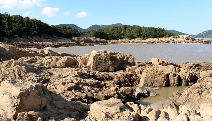
The geology of Putuo Mountain Scenic Spot belongs to the coastal zone of Eastern Zhejiang in the ancient Cathaysian fold belt. It was formed in the Jurassic-Cretaceous period 150 million years ago. The intrusive granite formed the rock foundation in the late Yanshanian movement. Its landform can be divided into mountain area, sea erosion terrace, sea erosion area and sea erosion area because of the intermittent uplift of the Tertiary neotectonic movement crust and the sea erosion during the Quaternary glacial and interglacial periods.
Mountainous area: low mountain area above 200 meters above sea level is about 0. 24 square kilometers. It accounts for 2% of the total area of the island, and the rest is hilly land below 200 meters above sea level. During the long geological age, hard granite was weathered and eroded, and developed along vertical and high-angle joints. The surrounding mountains collapsed, forming many isolated peaks and abrupt landscapes.
Marine erosion terraces: The island is a complete preservation of five-grade and three-grade marine erosion terraces, whose area accounts for 90% of the total area of the island, of which four-grade and five-grade marine erosion terraces are rounded, forming the main ridges of the island.
Marine deposits: Because of the difference of hydrodynamics and sediment distribution around the island, the northeast coast has strong hydrodynamic force, and the surge is directly close to the beach. The coast is dominated by sand and gravel beaches; the southwest coast has weak hydrodynamic force, and the intertidal zone accumulates a large amount of silt supplied by the Yangtze River, forming a broad mud beach. Beach: about 5.17 kilometers long, accounting for 22% of the island's coastline. It is distributed in Houlansha, Husha, Feisha, Qiansha, Baibusha and Jinsha in the north, East and south of the island. Sandy from shore to sea changes from coarse to fine, and from below intertidal zone to muddy.
Gravel beach: about 3.23 kilometers long, accounting for 14.3% of the island's coastline. It distributes in the northwest of the island, along the north coast of Gangdun and along the coast of Xiangyan in southeast of Feishao, and is mosaic in the bay. The gravel beach opposite the small cave in southeastern Feishao and Fulong Mountains is 20-30 meters wide and the rest is several meters wide. The diameter of gravel is usually between 0.50 and 1.5 meters, and the maximum is 1.5 to 2 meters. Because of the impact of surge and torrent, the gravel is rubbed into a muddy circle.
Mudflat: about 4.2 km long, accounting for 20% of the total coastline of the island. It distributes in the weak areas of wave and tidal currents, such as Short Gudao Head to Wind Tunnel Head in the south of the island, West Wind Tunnel Head to Liuemenshanzui in the west of the island, etc. It is formed by the deposition of suspended matter in the tidal currents along the Yangtze River Estuary and Zhejiang coast in the wave concealed area. The intertidal zone extends 400-1000 meters in width and slope is 2-3 degrees.
Sea erosion land: under the action of tide, tide and wave, sea erosion caves are formed and gradually expanded into sea erosion roadways, sea erosion niches, sea erosion cliffs and sea erosion platforms, which constitute bedrock shoreline with a total length of 9.9 kilometers, accounting for 44% of the island's total shoreline.
Sea Erosion Cliff and Sea Erosion Platform: Distributing around the island, it is more developed in the north and east, and the cliff wall is more than ten meters high. It is said that the ratio of ancient sea erosion to cliff can be seen in Taishi and Xinzishi, which are well preserved up to now. Sea erosion platforms are distributed on the margins of some marine terraces and rock pillars are upright.
Sea erosion cave roadway: distributed at the foot of sea erosion cliff. Due to the impact of surge, sea erosion cave gradually expanded into sea erosion roadway. Chaoyin cave, Fanyin cave and sea erosion roadway in front of Western Anqian are typical representatives.
Climatic characteristics
Putuo Mountain Scenic Spot belongs to the middle subtropical marine monsoon climate, which is characterized by warm winter and cool summer, distinct seasons, heavy wind and fog, abundant rainfall and abundant sunshine. According to the analysis of meteorological data in the past 20 years, the annual average temperature is 16.1 C, the monthly average temperature of the coldest month is 5.4 C, the monthly average temperature of the hottest month is 27 C; the daily extreme maximum temperature is 38.2 C, and the daily extreme minimum temperature is -6.5 C; the annual precipitation is 1186.9 mm, and the average number of precipitation days is 149.1; the precipitation in spring and summer is more than in autumn. Relative humidity ranged from 72% to 91%, annual sunshine hours averaged 2133.7 hours, monsoon was obvious, autumn was mostly northerly, spring and summer were mostly southerly, typhoon occurred in 7, 8 and 9 months, annual average wind speed was 4.2-5.7 m/s, maximum average wind speed was 31 m/s. The frost-free period was 254 days, and the average number of freezing days was 18.3 days. There is little snow.

Ask a Question
Your email address will not be published.
Latest Post
-
 Sunan Wenshu Temple Scenic Spot
 -
 Dong year
2019-04-27
-
 Architectural coloured drawing
2019-05-05
0 Questions