2019-01-12
- By ChinaWiki.net
- Chinese Edition
- 2018-12-12
Yunyang Longgang Scenic Spot: National AAAAA Class Tourist Spot, National Geopark and National Day 2016 "Best Tourist Service Scenic Spot", which is called the last "Shangri-La" of the Three Gorges of the Yangtze River by tourists, and is praised by outdoor enthusiasts as the "Xiaohua Mountain" of the Chongqing edition.
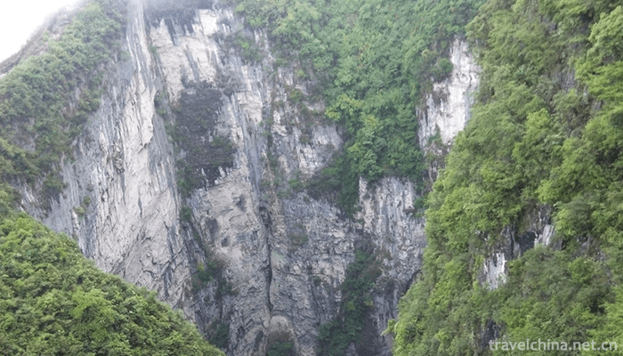
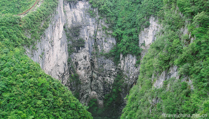
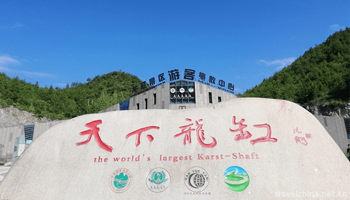
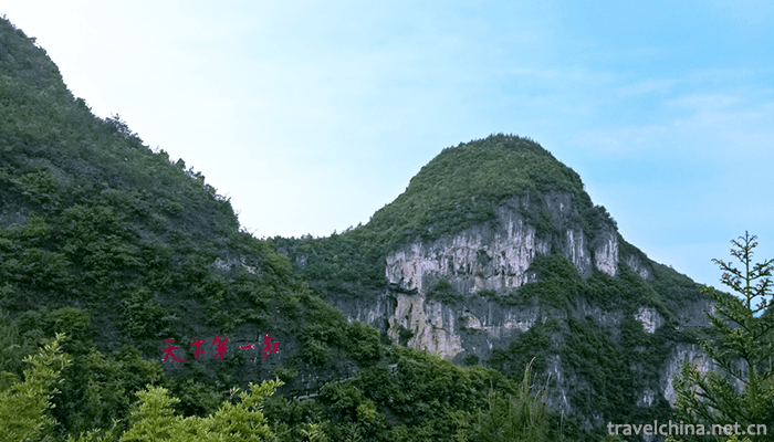
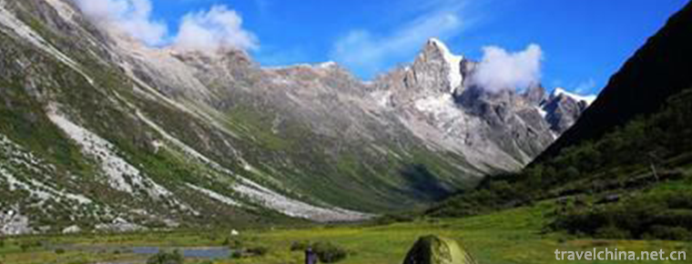
Yunyang Longgang Scenic Area is located in the southeast corner of Yunyang County, Chongqing City. It is close to Lichuan City, Hubei Province. It integrates Tiankeng, canyon, karst cave, alpine grassland, forest and Tujia customs. The main scenic spots include Longgang Tiankeng, Yunduan Langqiao, Longdong Scenic Spot, Longcave Gorge, Qishan Grassland, Youcao Ancient Great Wall, Qiyangguan Ancient Road Site, Xiaba Lake, etc. Among them, Longgang Tiankeng is 335 meters deep, ranking third in the country and fifth in the world. The wall of Longgang Tiankeng is arched by cliffs with a slope of nearly 90 degrees. This form of straight up and down is extremely rare in the world and enjoys the reputation of "the first cylinder in the world".
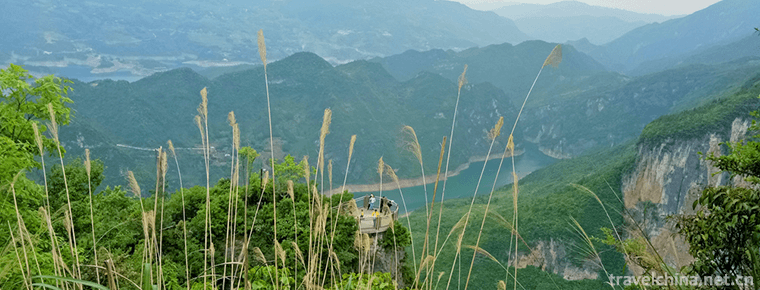
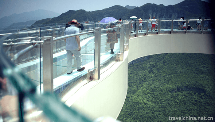
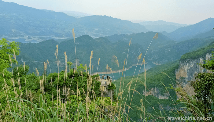
Yunyang Longgang Scenic Spot is built on the cliff of 1010 meters above sea level. It takes the petals of the "flower of the sky" as its shape, and can enjoy the beautiful scenery around 720 degrees on the bridge. Its cantilever length is 26.68 meters, the gallery bridge is 718 meters from the ground, 5.34 meters longer than the glass gallery bridge of Colorado Grand Canyon in the United States, and it is the longest cantilever glass gallery bridge in the world.
The Longgang Scenic Area in Yunyang is a museum of natural science and a grand garden of geological landscape, with its unique landform, dense karst caves, strange peaks and rocks, skyscraper stalagmites, dangerous and handsome, various and colorful features. Longguan has different scenery in four seasons. Flowers and plants in spring, waterfalls in summer, red leaves in autumn and snow in winter are all amazing. On February 25, 2017, it was newly promoted as a national 5A tourist attraction.
Location context
Chongqing Yunyang Longgang National Geopark is located in Qingshui Family Township, Yunyang County, on both sides of the Yangtze River in the northeast of Chongqing City, the hinterland of the Three Gorges Reservoir Area, Fengjie County in the east, Wanzhou District in the west, Wuxi County in the north, Kaixian County in the west, Lichuan City in Hubei Province in the south. It is located between 108 35 -109 14, 30 35 6 -31 26.
climate
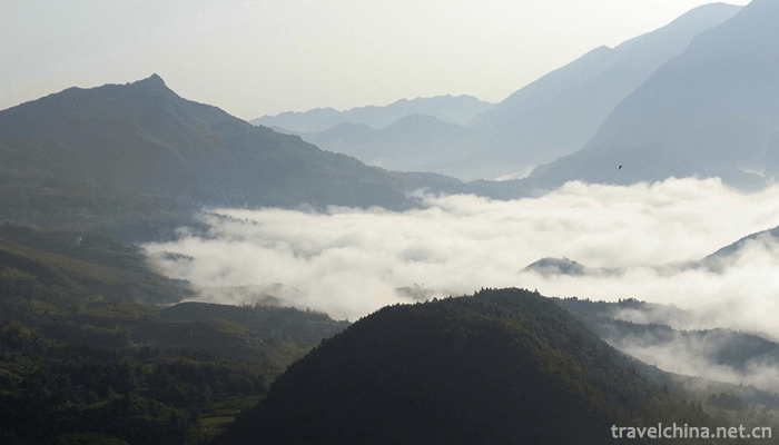
Located on the South Bank of the Yangtze River, the park has a mild climate, abundant rainfall, drought in spring, hot summer, continuous rain in autumn and winter, less sunshine, high humidity, cloudy and foggy, but long frost-free period. The average annual temperature is the coldest in January, generally 4 C-7 C, the hottest in July and August, and 30 C-32 C. The rainy season lasts from April to May and from September to October every year. In winter, Qiqishan Mountain in the southeastern corner becomes the windward side of inland dry and cold air mass, which is controlled by it, and precipitation is scarce; in summer, it is affected by the southwest monsoon warm air mass, and precipitation is more.
geology
Structural characteristics
The park is generally located in the fold zone between Huayingshan fault and Qiqishan fault, i.e. the southeast corner of the Parallel Ridge Valley in Eastern Sichuan. The pre-Yanshanian tectonic layers are in conformity and pseudo-conformity contact, and the tectonic movement mainly shows obvious ascending and descending movement. The late Yanshanian fold structure is remarkable, which is unconformity contact between the Upper Cretaceous and underlying strata, and the structural form is mainly fold deformation. 。 It is located in the transitional zone between the eastern Chongqing fold belt and the Hunan, Hubei, Sichuan and Guizhou uplift fold belt. The study area is located in NE-SW trending tectonic belt. The northern margin of the study area is obliquely joined and reconnected with NW trending Dabashan arc structure. It is a part of the thin-skinned structure formed by the Indosinian-Himalayan movement. The main manifestation is the partition structure formed by wide and flat box (drawer) syncline and sharp and narrow anticline, while in the axis of anticline, some joint fissures or compressive-torsional fractures of different scales are easily formed due to stress concentration.
Strata and lithology
The outcropping strata in the park are Triassic, Jurassic and Quaternary of Cenozoic. Triassic is the main stratum exposed in the park. Its lithology and thickness vary greatly. The lower Jialingjiang Formation limestone is widely distributed in the park. The Middle Badong Formation is shallow marine clastic rock and argillaceous limestone, partially mixed with gypsum and copper-bearing sandstone; the Upper Xujiahe Formation is inland lacustrine clastic rock and produces coal.
Cause analysis
Longgang Scenic Area is dominated by typical karst landforms. Under the action of karst, gravity collapse and water erosion, it has formed a variety of landscapes and strange peaks and rocks. Dragon cylinder is a fractured zone formed at the intersection of three sets of joints and cleavage at the northeastern turning point of syncline, and then formed by repeated dissolution-collapse-dissolution-collapse of groundwater in the cave.
Longgang karst heavenly pit attracts worldwide attention as a typical representative of karst geomorphology. Its main cause is karst collapse and dissolution. The heavenly pit is located at the intersection of multiple sets of joints and cleavages. Rocks are very fragile. In these strata, multi-layered karst caves formed by water-flow erosion are crisscrossed and crisscrossed. Under the action of natural gravity, rocks in the fractured zone collapse, and collapses are immediately dissolved by dark rivers. Corrosion takes away, so the Longguan Tiankeng is formed gradually in repeated corrosion-collapse. In Longgang National Geopark, there are many karst caves with different locations and heights. By studying the stratification of several caves in the area, the evolution history of erosion datum can be analyzed and the stable and shear periods of rivers can be inferred.
CHARACTERISTICS OF GEOLOGICAL REMAINS
(1) Da'an Cave, which belongs to the landscape of karst landscapes, has the lithology of limestone of the lower Triassic Jialingjiang Formation. Its roof is dome-shaped, and its opening is located in the karst trough valley. It is a layer karst cave, and the trough valley is NE-SW oriented.
(2) The Huangling Gorge, which belongs to the water landscape, is developed in the core of Huangling Gorge anticline. The peak forests on both sides of the valley are beautiful, and the trending of folds and faults is distinct. The geological movement signs are very obvious. Ten thousand volumes of poems in the canyon are a geological wonder produced by two strike-slip faults in limestone pushing relatively flat strata to near-upright position.
(3) The Yikou Stone, located on the shore of the stalagmite river, is composed of Triassic Jialingjiang Formation limestone. The dissolution widens the vertical fissures and leads to collapse, forming the geological wonder of Yikou Stone today.
(4) Insect traces of fossils belonging to paleontological landscapes are a set of marine carbonate sediments in the Triassic Jialingjiang Formation limestone. They are gray in color, and insect traces are found everywhere, and they are well preserved.
Main attractions
Overview
The scenic spot is a museum of natural science and a Grand View Garden of geological landscape with its unique landform, dense caves, strange peaks and rocks, high-speed stalagmites, dangerous and handsome, diverse and colorful. The main attractions are Longguan, Longdong, Laozhai, Yingyue Cave, Stalagmite River, Laoyuxia Gorge, Huangling Gorge, Longcao Gorge, Volcanic Gorge, Tibetan Dragon Gorge, Qishan Grassland (Forest), Old Great Wall of Magnolia, Qiyangguan Ancient Road Site, Xiaba Lake, etc. It combines all kinds of charms, such as grandeur, wonder, danger, steepness, seclusion, quietness and beauty.
Dragon cylinder
Longgang is an elliptical karst sinkhole formed mainly by karst collapse and secondly by karst erosion. The olecranon peak at the lowest point of the Dragon cylinder mouth was measured at an altitude of 1113 m, extending about 304-325 m in the direction of the long axis near 70 degrees and 178-183 m in the direction of the short axis, with a depth greater than 335 M. Its depth is second only to Xiaozhai Tiankeng and Dashiwei Tiankeng in China, ranking third in China and fifth in the world.
If the inner wall of the Dragon cylinder is cut, the cylinder wall is arched by a cliff. The widest part is more than 2m, and the narrowest part is less than 40cm. People stand on the edge of the cylinder, one side is the wall of a thousand jars, the other side is the abyss of ten thousand feet. Pine branches lie in the cracks, vines hang upside down, jungle is green at the bottom of the cylinder, emerald all the year round. Hundreds of birds in the forest contend, circling low-flying, smoke rising, beautiful scenery, known as "the world's first cylinder". As far as the depth and diameter are concerned, the Dragon cylinder is a super heavenly pit with high value of sightseeing, exploration tourism and scientific research.
Moon cave
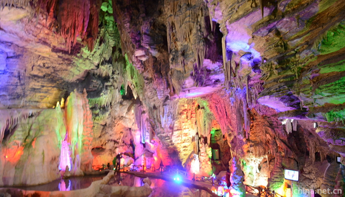
Yingyue Cave is located in the cliff of 100m northeast of Longguan, which is the first layer of karst cave. The length of the cave is 43m, the direction is 25 degrees south, the diameter is 3.9m, the north is 2.2m, and the north end is the outlet of the dark river. There are troughs and valleys formed by running water. There are some stalactites and travertine on the top of the cave. There are also water droplets along the stalactites at the South end of the cave, forming a catchment pit about 50cm deep underground. Every Mid-Autumn night, the moon rises from the East soon, the moon fills the whole cave body, the cluster of silver light like a flashlight, from north to south through the hole, people call this strange landscape "piercing the hole reflects the moon".
Qishan grassland
Qishan grassland is a mountain-type natural scenic spot. It is a city-level Forest Park in Chongqing. The sea level is between 1,000 meters and 1,650 meters. It is a karst mountain with an area of 12.5 square kilometers. The scenic area has primitive forests and alpine grasslands. Primitive forests are mostly pine, fir and cypress forests, among which there are precious tree species such as metasequoia, ginkgo, iron green bars, red beans and some unknown shrubs, which can be called the world's plant living fossils.
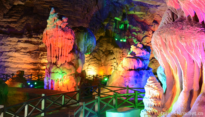
Dragon Cave
Longdong consists of two halls, the front hall is round, 40 meters wide, nearly 50 meters high, 120 meters long, covering an area of 4,800 square meters, with a variety of stalactites, magical and magnificent, dazzling. There are "Baiyulong Bed", "Dragon Umbrella", "Dragon Pot", "Dragon Chair", "Dragon Bench", "Liantai", "Tianji Dawn" and other natural landscapes. The back hall is pentagonal, 30 meters high, 300 meters long and 6000 square meters in area. Inside, the stalactites are like lions, elephants, dragons and phoenixes, with teeth and claws open and wings spread.
Shi Mao River
The stalagmite river is the most beautiful section of the Changtan River. It covers 12.5 kilometers from the north to the south to Shuanghekou. It is a canyon landscape of karst landform. Cross-strait, such as cut caves, stalagmites skyscraper, illusion of such as flying sky, village aunt, Luohan and other figures; river water is clear and bright, rich in turtles, roundfish, or waterfalls or springs, scattered in the meantime, Qisong, Cuiper, Youbamboo, fir and other plants shade the sky, Huang Jing, Tianma, Fritillaria, Coptis and other valuable medicinal materials are all over the mountains, yellow sheep, sweet deer, yellow muntjack, golden monkey, wild boar and other walks in the forest* In the meantime, pheasants, orioles, cuckoos, kingfishers and parrots are singing in their fields. Stalagmite River is located in the transitional zone between the eastern Chongqing fold belt and the Hunan-Hubei-Sichuan-Guizhou uplift fold belt. In the Cenozoic era, 67 million years ago, due to the uplift of the crust and the downcutting of the river, under the combined action of physical, chemical and biological forces, the multi-layer caves formed by flowing water and dissolution are crisscrossed and crisscrossed. In the repeated erosion-collapse-erosion-dissolution-collapse process, the rocks on the surface are formed. Buds, peaks, funnels and underground three layers of karst caves have their own system. The relative elevation difference between the ridges and valleys is more than 1400 meters, forming a spectacular karst landscape and mysterious Canyon landscape.
Cloud covered bridge
The Longgang Scenic Area in Yunyang, Chongqing, has built a 26.68m (21.68m) cantilevered view gallery bridge on the cliff at 1010.5 m above sea level. The vertical height of the cliff is 700m. Taking the petals of "the flower of the sky" as the design idea, three layers of high-strength glass are used at the bottom of the gallery bridge, and visitors can enjoy the beautiful scenery around 720 degrees standing on the gallery bridge. The cantilever length of Yunduan Corridor Bridge will surpass that of the Colorado Canyon Glass Bridge in the United States (extending 21m from the rock wall) and become the world's first cantilever glass bridge. It will be an important element of the future external logo and business card of the scenic spot and the cultural framework of 5A scenic spot.
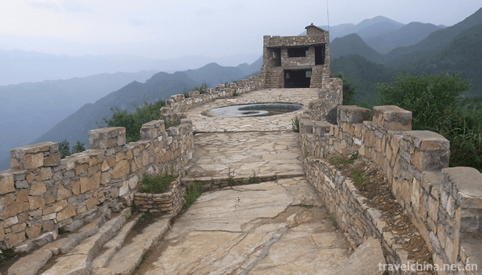
Old
stockade
Lao Zhaizi is located on the southwest side of Qingshui Township. It is a cultural relic site located on a knife ridge. The rock type is Triassic Jialingjiang Formation limestone. The rock is thick and gentle. The village is located at the highest point on the top of the ridge. There are existing ancient towers, stone gates, numichi, collapsed sacrificial dragon pillars and Hulou sites. Lao Zhaizi is located on the top of the mountain, which is 5-10m wide and 50m long. Standing on the top of the mountain, we can see the whole picture of the stalagmite River and the stalagmites hundreds of meters high to the west, the Longtangkou to the north and the two estuaries to the south. Farming scenery and stone buds are to the east. Here we have the opportunity to enjoy the beautiful scenery of Longguan Buddha's golden body and Luoxia's melting gold.
Da'an cave
Da'an Cave is a large limestone karst cave, also known as Yuquan Cave. It is located in the cliff on the West Bank of the stalagmite river. It is about 200 meters below the mouth of the cave and about 100 meters above the top of the cliff. There is a seasonal waterfall on the south side of Dongkou. Every rainy season, the waterfall falls and then converges into the stalagmite Hanoi. The main direction of the main cave is 160 degrees south. The cave mouth collapses to form a hall. The hall is about 50m high and dome-shaped. The length of the cave is more than 3000 meters. The cave is connected by nine caves. The wonders of each cave include inverted golden monkeys, welcoming pillars, Ding Hai Shen Needle, Jinyin Waterfall, sand beach, stalagmite exhibition, racetrack, art gallery, sea lion shrine, etc. Formed from natural limestone, it is known as "the first hole in the world".
Development and construction
In 2004, the relevant departments of Yunyang began to organize experts to develop geological resources such as Tiankeng Longguan, and carried out the first comprehensive survey of Chongqing Longguan Geopark. The tourism resources in the region were sorted out in detail.
In 2004, the Yunyang County Government officially launched the Longgang Geopark declaration work, which played a very positive role in the protection of geological resources in the region. At the same time, more people began to pay attention to these unique resources.
In February 2005, in order to develop scenic spots, planning should go ahead. The leading group of Yunyang, who are deeply familiar with this principle, began to carry out the park planning work intensively and completed the "Longgang Geopark Master Plan".
In August 2005, the Ministry of Land and Resources of the State Council officially granted Yunyang Longgang Geopark National Geopark qualification, which is both a positive and a promotion for the future development of the park.
In October 2007, Longgang National Geopark officially started construction, set up park boundary markers, and built and improved the infrastructure of the park.
September 2008, with the needs of tourism development. On the basis of fully protecting the park's geological tourism resources, the compilation of "Longgang National Geopark Tourism Master Plan" was completed to promote the construction and development of the park.
In April 2012, the Longgang National Geopark Hypothesis has achieved preliminary results, officially opened to visitors, and ushered in a small climax of tourism during May Day, which is a great encouragement to the park, indicating that the park is very attractive in the market;
In November 2012, through a series of efforts, the Dragon Cylinder Scenic Area of the park was officially rated as the national AAAA-level scenic area. Now the park is actively preparing for the development of the other two blocks and the creation of AAAAAAA for Dragon Cylinder Scenic Area.
In March 2014, the Yunduan Corridor Bridge, with a total investment of more than 350 million yuan, was constructed. The most advanced wind-resistant and shock-absorbing technologies were used to resist gales and earthquakes of magnitude 8.
On May 1, 2015, the Cloud End Corridor Bridge officially opened its doors to welcome visitors.
In December 2016, Yunyang Tourism Bureau introduced Beijing Carbin Skiing Co., Ltd. to build a ski resort of 60,000 square meters in Longgang Scenic Area. Skiing resort is divided into five core functional areas: core skiing area, playful snow area, leisure and sightseeing area, service supporting area and infrastructure area. After the completion of the ski resort, it will become the largest ice and snow tourism resort in Chongqing.
Historical legends
Origin of Yingyue Cave
Legend has it that Zhang Guolao will feast the other seven immortals, taste his immortal wine on the night of Mid-Autumn Festival, and recite poems in the moonlight, which is a grand occasion of Wang Xizhi's Orchid Pavilion. However, after several rounds of wine, no moonlight was seen. The immortals laughed at him with wine. Zhang Guolao would rush to the sky in a hurry to find the moon. As a result, he ran to the Dragon VAT and saw the moon embedded in the hole, so he tried his best to push the moon out and back to the sky. Zhang Guolao exerted himself too much and stepped out a pair of deep pits in the hole, leaving his footprints in straw shoes. If the road inside the cave had not been paved with stones, we could have seen it as true and seen it as soon as possible.
Tourism information
Ticket information
Full vote: 100 yuan per person (October 1, 2018); Half vote: 60 yuan per person.
Opening Hours
Ticket sales and admission time: 7:00-15:00 (summer); 8:00-14:00 (winter)
Closing time: 19:00 (summer); 18:00 (winter)
Traffic information
Passenger line
Chongqing North-Yunyang (Lianhua Station), turn to Yunyang (Dongcheng Station) - Qingshui bus to reach the scenic spot, the whole journey takes about 5.5 hours;
Chongqing North-Wanzhou, Wanzhou-Qingshui bus arrives at the scenic spot, the whole journey takes about 5.5 hours.
Self-driving tour route
Chongqing departure: The main urban area departs into Shanghai-Chongqing Expressway. The expressway is about 300 kilometers under Yunyang Road. The toll is about 200 yuan. Then it takes the National Highway to Lichuan and reaches the scenic spot through Panshi, Fengming, Longjiao and Qingshui. The whole journey is 375 km/6 hours and 51 minutes.
Chengdu departure: The main city departs into Hurong Expressway, passes through Guang'an, Dianjiang, Shanghai and Chongqing Expressway, goes down Yunyang Road, then to Lichuan direction, and arrives at the scenic spot through Panshi, Fengming, Longjiao and Qingshui. The highway is about 550 kilometers and the toll is about 350 yuan. The whole journey is 635 km/10 hours and 14 minutes.
Dazhou departure: take Baomao Expressway (G65) to Linshui, then Shanghai-Chengdu Expressway (G42) to Yunyang, and take Yunli Road to reach the scenic spot through the Yangtze River Bridge on Yunyang Lower Road. You can also take a train from Dazhou to Wanzhou, and then take a train from Wanzhou to Qingshui to the scenic spot.
Wuhan departure: The main city departs through the Third Ring Road into Shanghai-Chongqing Expressway, and reaches Lichuan through Xiantao, Qianjiang, Jingzhou and Enshi. The expressway is about 550 kilometers. The toll is about 200 yuan. Then take the national highway and reach the scenic spot through Boyang and Qingshui. The whole journey is 600 km/8 hours and 30 minutes.
Ask a Question
Your email address will not be published.
Latest Post
-
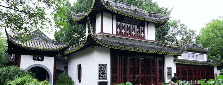 Guyi Garden
 -
 Jiali Folk Stories
2019-05-05
-
 Ningxia Xiaoqu
2019-06-08
0 Questions