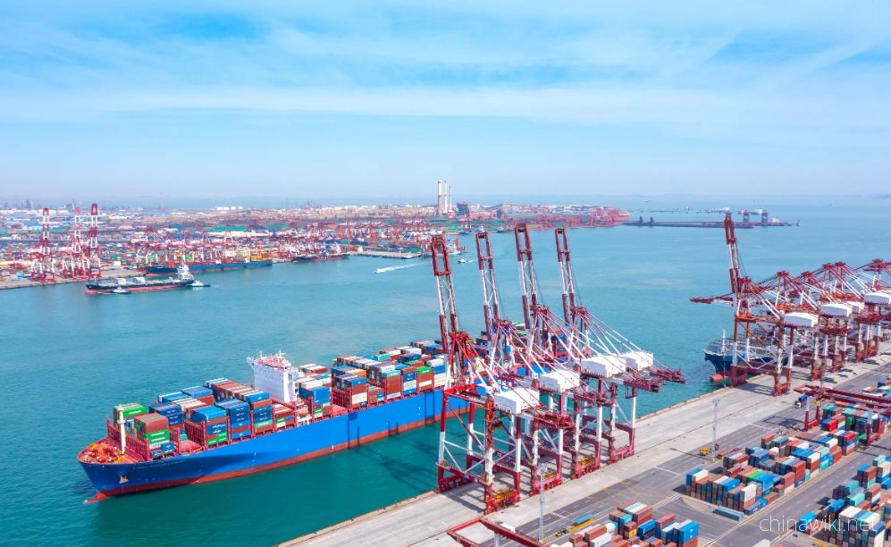
Port resource situation in Jiangsu
As of the end of 2021, jiangsu Province had 5909 productive port berths and 529 berths of over 10000 tons. The comprehensive annual throughput capacity of ports reached 2.38 billion tons, and multiple indicators such as port cargo throughput capacity and berths of over 10000 tons ranked first in the country. As the only province in China that has both river ports, seaports, and river ports, jiangsu is transforming from a major port province to a strong port province. As of 2022, jiangsu Province has 6406 productive berths in ports, 560 berths of over 10000 tons, 7 ports with a capacity of 200 million tons, a comprehensive annual throughput of 2.62 billion tons, and an annual throughput of 3.24 billion tons, all ranking first in the country
-
1.Jiangsu Province during the Ming and Qing Dynasties
In 1368, Zhu Yuanzhang established a political power in Yingtian (now Nanjing) as the capital city. Later, Yingtian changed its name to Nanjing and then to Jingshi, also known as Zhili. After Ming Chengzu established the name Yongle, he moved the capital
Time 2024-12-28 -
2.Location and territory of Jiangsu Province
Jiangsu Province is located in the middle of the eastern coastal area of Chinese Mainland, at the lower reaches of the Yangtze River and Huaihe River, bordering the Yellow Sea to the east, Shandong to the north, Anhui to the west, and Shanghai and Zhejian
Time 2024-12-28 -
3.Climate situation in Jiangsu Province
Jiangsu belongs to a transitional climate from temperate to subtropical, with the Huai River and the main irrigation canal in northern Jiangsu as the boundary. To the north, it belongs to a warm temperate humid and semi humid monsoon climate, while to the
Time 2024-12-28 -
4.Geological conditions of Jiangsu Province
Jiangsu Province is located in the North China plate, the eastern section of the Qinling Dabie orogenic belt, and the Yangtze plate, which cross the Chinese Mainland. The regional geological background and tectono magmatic activity are obviously different
Time 2024-12-28 -
5.The topography and geomorphology of Jiangsu Province
The terrain of Jiangsu Province is mainly plain, with a land area of 103229.17 square kilometers. Among them, the plain area accounts for 86.89%, reaching 89706.03 square kilometers, the hilly area is 11916.16 square kilometers, and the mountainous area i
Time 2024-12-28 -
6.Soil conditions in Jiangsu Province
The natural factors such as climate, geological landforms, parent materials, and vegetation that contribute to the formation of soil in Jiangsu are relatively complex. Soil resources are abundant and diverse, with zonal soils mainly distributed in mountai
Time 2024-12-28 -
7.Water Resources Situation in Jiangsu Province
Jiangsu has abundant water resources, with annual runoff depth ranging from 150-400 millimeters during rainfall. Deep Quaternary loose deposits are widely distributed in the plain areas of Jiangsu Province, with abundant groundwater sources. The total
Time 2024-12-29 -
8.Land Resources in Jiangsu Province
In December 2021, the main data bulletin of the third national land survey in Jiangsu Province showed that there were 61.4839 million mu of arable land in the province, including 42.5758 million mu of paddy fields, accounting for 69.25%; 11.2311 million a
Time 2024-12-29 -
9.Forest Resources in Jiangsu Province
In 2017, the forest area in Jiangsu Province was 1.56 million hectares, with a forest coverage rate of 22.9% and a total standing timber volume of 96.09 million cubic meters. There are 6 national forest cities (Wuxi, Yangzhou, Xuzhou, Nanjing, Zhenjiang,
Time 2024-12-29 -
10.Wetland Resources in Jiangsu Province
In 2017, Jiangsu Province had 2 internationally important wetlands, 5 nationally important wetlands, and 64 wetland parks at or above the provincial level, including 26 national wetland parks and pilot projects, and 38 provincial-level wetland parks
Time 2024-12-29 -
11.The situation of marine resources in Jiangsu Province
The Jiangsu sea area is located in the central northern part of China's sea area, at the center of the western Pacific coast, facing South Korea and Japan across the sea. It has a superior geographical location and an important strategic position, with a
Time 2024-12-29 -
12.Port resource situation in Jiangsu
As of the end of 2021, Jiangsu Province had 5909 productive port berths and 529 berths of over 10000 tons. The comprehensive annual throughput capacity of ports reached 2.38 billion tons, and multiple indicators such as port cargo throughput capacity and
Time 2024-12-29