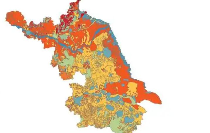
Soil conditions in Jiangsu Province
The natural factors such as climate, geological landforms, parent materials, and vegetation that contribute to the formation of soil in jiangsu are relatively complex. Soil resources are abundant and diverse, with zonal soils mainly distributed in mountains, hills, and hills, with elevations usually above 20 meters. These soils mainly include brown soil, brown soil, yellow brown soil, yellow brown soil, brown red soil, tidal soil, paddy soil, sand ginger black soil, coastal saline soil, lime soil, dark soil, purple soil, swamp soil, etc. Due to the close relationship between the selection of water-saving agriculture technologies and soil clay content, soil clay, loam, and sandy soil can be classified into three categories based on different soil clay content.
-
1.Jiangsu Province in the Pre Qin Period
Archaeological discoveries indicate that humans existed on the land of Jiangsu as early as the Paleolithic era, and cultural sites from the New Era have also been discovered in various parts of Jiangsu. During the Xia, Shang, and Zhou dynasties, the Jiang
Time 2024-12-28 -
2.Jiangsu Province during the Qin and Han Dynasties to the Southern and Northern Dynasties
After Emperor Qin Shi Huang unified China, the system of prefectures and counties was implemented. During the Qin Dynasty, the northern part of Jiangsu Province was divided into Sishui County, Donghai County, and Langye County, while the southern part of
Time 2024-12-28 -
3.Jiangsu Province during the Ming and Qing Dynasties
In 1368, Zhu Yuanzhang established a political power in Yingtian (now Nanjing) as the capital city. Later, Yingtian changed its name to Nanjing and then to Jingshi, also known as Zhili. After Ming Chengzu established the name Yongle, he moved the capital
Time 2024-12-28 -
4.Jiangsu Province during the Republic of China period
In 1912, the Republic of China established a provisional government in Nanjing, with Sun Yat sen serving as the interim president. In April of the same year, Yuan Shikai usurped the fruits of the revolution, and Jiangsu fell into the sphere of influence o
Time 2024-12-28 -
5.Jiangsu Province after the establishment of the People's Republic of China
In June 1949, the entire Jiangsu province was liberated. The territory is divided into three provincial-level administrative regions: northern Jiangsu, southern Jiangsu Administrative District, and Nanjing City. In January 1953, three provincial-level adm
Time 2024-12-28 -
6.Climate situation in Jiangsu Province
Jiangsu belongs to a transitional climate from temperate to subtropical, with the Huai River and the main irrigation canal in northern Jiangsu as the boundary. To the north, it belongs to a warm temperate humid and semi humid monsoon climate, while to the
Time 2024-12-28 -
7.Geological conditions of Jiangsu Province
Jiangsu Province is located in the North China plate, the eastern section of the Qinling Dabie orogenic belt, and the Yangtze plate, which cross the Chinese Mainland. The regional geological background and tectono magmatic activity are obviously different
Time 2024-12-28 -
8.Hydrological and Water Conservancy Situation in Jiangsu Province
Jiangsu Province spans across rivers and coasts, with numerous lakes and a dense water network, adjacent to land and sea. It is the only province in China with large rivers, lakes, and seas. The Yangtze River spans 433 kilometers from east to west, and th
Time 2024-12-28 -
9.Soil conditions in Jiangsu Province
The natural factors such as climate, geological landforms, parent materials, and vegetation that contribute to the formation of soil in Jiangsu are relatively complex. Soil resources are abundant and diverse, with zonal soils mainly distributed in mountai
Time 2024-12-28 -
10.Wetland Resources in Jiangsu Province
In 2017, Jiangsu Province had 2 internationally important wetlands, 5 nationally important wetlands, and 64 wetland parks at or above the provincial level, including 26 national wetland parks and pilot projects, and 38 provincial-level wetland parks
Time 2024-12-29 -
11.The situation of marine resources in Jiangsu Province
The Jiangsu sea area is located in the central northern part of China's sea area, at the center of the western Pacific coast, facing South Korea and Japan across the sea. It has a superior geographical location and an important strategic position, with a
Time 2024-12-29 -
12.Biodiversity situation in Jiangsu
On April 30, 2019, the official website of the Department of Agriculture and Rural Affairs of Jiangsu Province announced that Jiangsu Province has abundant plant resources, with over 2200 species belonging to 672 genera in 157 families of seed plants, ove
Time 2024-12-29