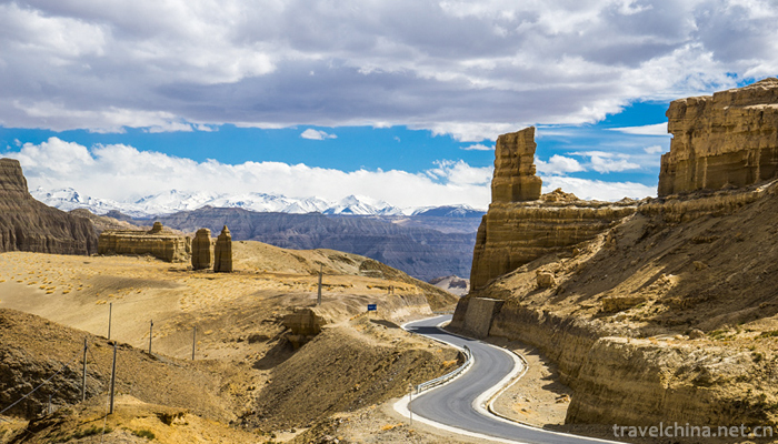
Zanda Tulin National Geological Park
Tibet Zanda earth Forest National Geopark is located in Zanda County, Ali Prefecture, southwest of Tibet autonomous region. In August 2005, the Ministry of land and Resources approved the fourth batch of national geological parks. It is a comprehensive geological park featuring a stone forest composed of red Ordovician carbonate rocks, as well as karst canyons, caves, lakes, springs and waterfalls. Including Hongshi Lin Karst Landform Scenic Spot, sitting Dragon River Gorge Scenic Area and Yifeng Lake Youshui river water body physiognomy scenic spot.
Located in the Tibetan Autonomous Region known as the "Roof of the World Ridge", the park is located in Pulan County to the east, Kashmir to the west, the Himalayas to the South and India to the north, Ayila Mountain to the north and Gar County to the center of Tolin Town, along the banks of the Xiangquan River, is a land characterized by soil forest landforms as the main geological relics. Texture and appearance of national geological park.
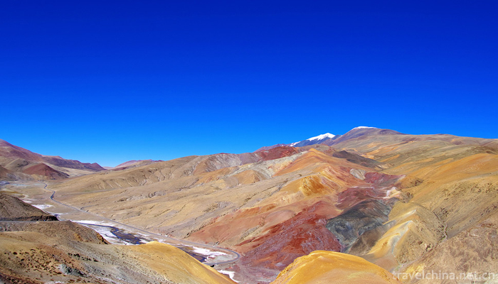
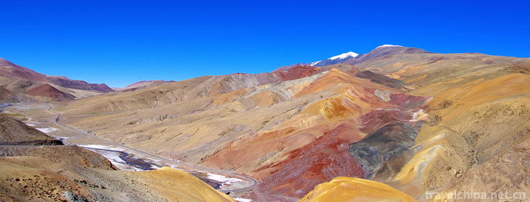
Distribution altitude is 3750 ~ 4450m, is the largest and most typical Neogene stratum weathering soil forest in the world. The geographical position is: 31 20 31 40 North latitude, 79 25 80 02 East longitude, and the total area of work area is 457.12 km.
Zhada Tulin National Geopark is situated at the junction of China and Kashmir, India and Nepal, 1500km from Lhasa City, there are about 700 km of sand and stone roads; 280 km from Shiquanhe Town, the seat of the Ali Regional Administration, of which about 120 km is Panshan sand and stone roads and dirt roads. The road is narrower and the road condition is poor. Tar oil is being built on this section of the highway. The road is expected to be opened to traffic in 2 years. The county has a total distance of 1065 km, including 219 national highways to Xinjiang, 318 national highways to Lhasa, the capital of the autonomous region, via Baer and Zhongba. Zanda County town leads to 6 villages and towns are all simple roads. Whenever the rainy season comes, some sections of the road can not be opened to traffic. So far, the county has poor overall traffic conditions.
Hydrology:
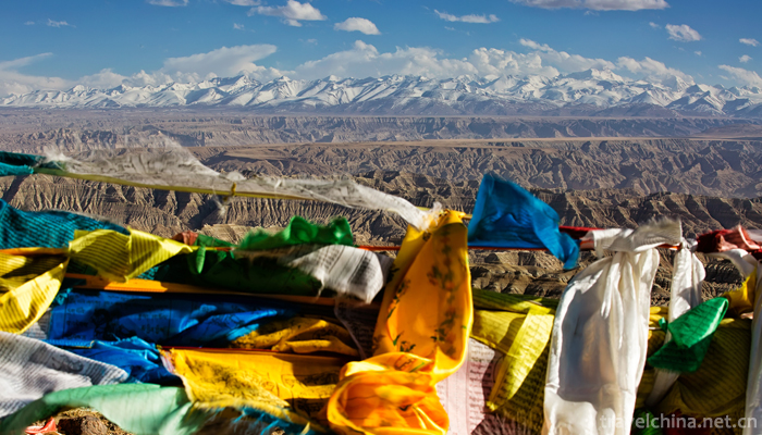
There are 14 large and small rivers in the territory, of which the Xiangquan River (known as the "Langqin Zangbu" in Tibetan) is the largest river flowing through the Zanda Basin, and the three outflow rivers in Zanda County have the largest average annual runoff. It originated from the Himalayan glaciers near the Lanta in the eastern part of Zanda County, because the mouth of the spring is shaped like an elephant cirrus. It is called the Quan river. After flowing through Qusundo, Torin and Ruba, it crosses the Himalayas west of the Shbuqi Pass and flows into India. It is renamed the Sutreki River. Xiangquan River has given birth to the brilliant Xiangxiong culture, Guge civilization, and magnificent landscape of earth forest.
Climate:
The climate of Zanda Basin is a plateau temperate monsoon arid region, which is greatly influenced by the alternation of westerly circulation and southwest monsoon. When the westerly circulation with the characteristics of climate subsidence prevails, Zanda presents the characteristics of dry climate, less precipitation, severe temperature difference and strong wind, and becomes the main weather system in winter. The southwest monsoon in summer enters over Zanda in early June or mid-June, which is characterized by warm climate and concentrated rainfall. The huge barrier action of the Himalayas on the south side of the Zanda Basin hinders the northward movement of the warm and humid currents to a great extent, thus making the Zanda Basin a "rain shadow area", and the annual precipitation is only about 160mm. Under the influence of the thermal effect of the valley basin, the climate in the Zanda basin has become very dry and hot. According to relevant meteorological data, the average annual temperature in Ali area is 3 C, and the average temperature in the hottest month (July) is 13.7 C. The monthly average temperature of the coldest month (January) is - 9.2, the days greater than 0, 230 days, 110 days greater than 10, the frost-free period is 124-130 days, and the annual sunshine hours are about 3,500 hours.
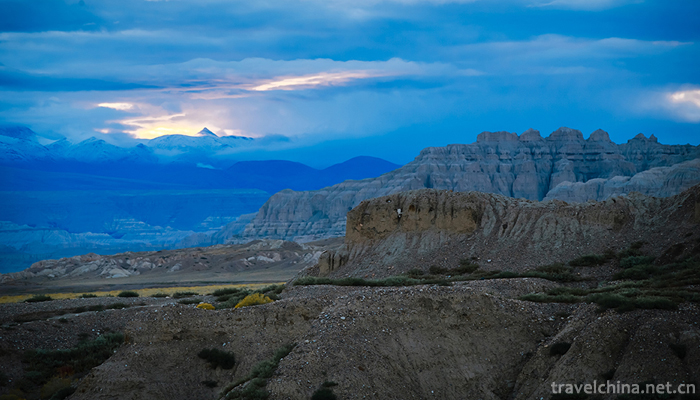
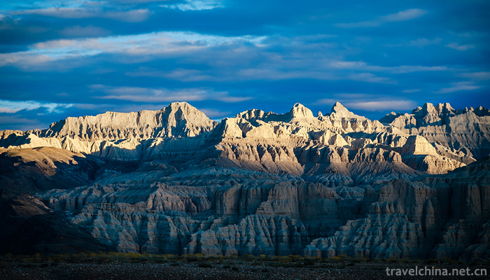
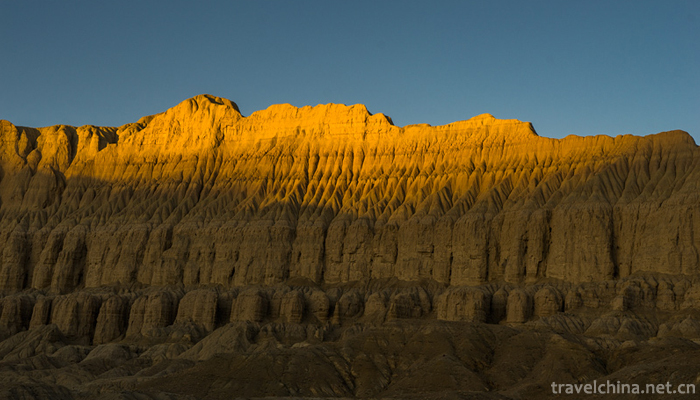
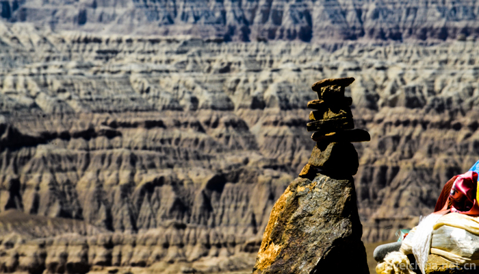
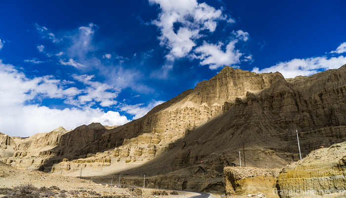
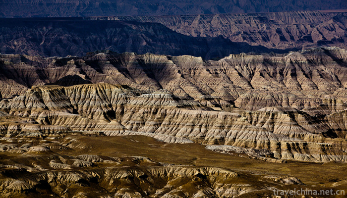
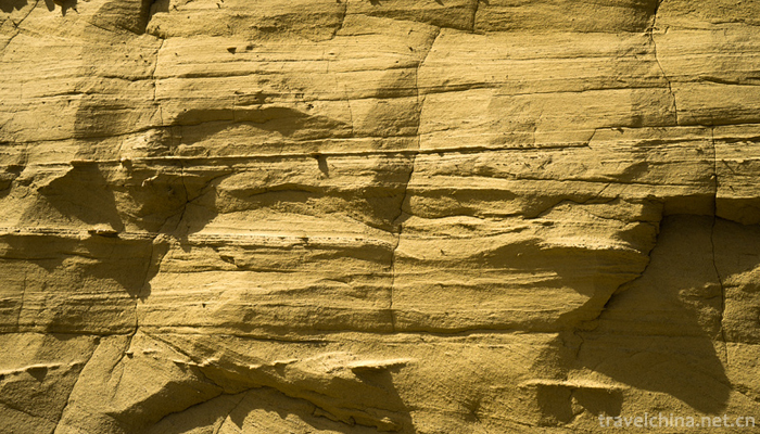
There are various types of geological relics in Zanda Tulin National Geopark, but the most representative one is the soil forest landforms occurring in the Zanda Group of Tertiary Pliocene to Quaternary Lower Pleistocene in Zanda Basin. Due to the differences in weathering resistance of various bedrock along the edge of the Zanda Basin, different landforms such as the number, scale, extension length and slope gradient of the tributaries and tributaries along the two banks of the Quanhe River are formed. The semi-consolidated rocks in the fluvial and lacustrine facies are formed after long geological evolution, such as undulation, overlapping of layers of forest and gas. The potential of the earth forest landscape. From a high point of view, the earth forest under the blue sky and white clouds stretches for hundreds of kilometers, stretching continuously and magnificently, like the ancient Gugexiong divisions marching in this vast land of Zada, making people solemn, solemn and solemn. The soil forest in Zanda area is the most typical, well-preserved, most peculiar and most widely distributed Tertiary stratum weathering soil forest landform found in the world. It is a typical area to study the development and evolution of soil forest landform.


-
1.Jiayuguan cultural relics scenic spot
Jiayuguan: World Cultural Heritage, National AAAAA Tourist Scenic Spot, National Key Cultural Relics Protection Unit, National Patriotic Education Demonstration Base.
Time 2018-12-12 -
2.Beijing Wildlife Park
Beijing Daxing Wildlife Park is located in the 10,000 Mu forest of Yuyuan Town, Daxing District. It is a large natural ecological park with animal protection, wildlife domestication and breeding and p
Time 2018-12-26 -
3.Sun Tzu Cultural Park
Sun Tzu Cultural Park is located in the East New Area of Guangrao County. It has been listed in the "four batches" key dispatching and promotion projects of the Yellow River Delta High Effic
Time 2019-02-13 -
4.Tengtou Ecological Tourism Area
Embedded between Fenghua and Xikou, Tengtou Eco-tourism Area is located in Xiaojiang Plain, close to Jiangba and Yongxi Highway. Located 6 kilometers north of Fenghua City
Time 2019-02-13 -
5.Weishan Lake National Wetland Park
Weishan Lake National Wetland Park, located in the southern part of Weishan County, Jining City, Shandong Province, is less than 3 kilometers away from the urban area.
Time 2019-02-22 -
6.Five major tunes in southern Shandong
The five major tunes in southern Shandong, also known as Tan Ma Diao and Tan Ma Diao, are traditional folk song suites that are active in Tancheng County, Linyi City, Shandong Province, with Tan Town
Time 2019-05-15 -
7.Wooden drum dance
Wood drum dance is a kind of folk dance that is spread among the Miao, Yi and Wa people in southwest China to dance and sacrifice by beating wood drum. Its drum shape is mostly to intercept the trunk
Time 2019-06-06 -
8.Han Yu
Han Yu (768 - 824 December 25th) retreated. Henan Heyang (now Henan Province Mengzhou People. Claiming to be "Changli," the world is called "Han Changli" and "Mr. Changli"
Time 2019-09-07 -
9.Four famous Chinese embroidery
Suzhou embroidery is famous for its fine stitches, elegant colors and fine embroidery. It has the characteristics of flat, light, even, harmonious, fine and dense. The theme is mainly about small animals. Such as "cat play", "wind through flowers",
Time 2020-12-12 -
10.Chengdu Giant Panda Base tourist service
The tourist center is located 40 meters to the left of the entrance door of the scenic area (first floor of the Giant Panda Museum), with a building area of more than 400 square meters.
Time 2020-12-13 -
11.Meishan administrative division
Meishan City has 6 county-level administrative divisions (Municipal District 2, county 4), and 80 township level administrative divisions (street 13, town 62, township 5). It covers an area of 7134 square kilometers and has a population of 3.5 million. Meishan Municipal People's Government in Dongpo District Meizhou Avenue West Section 2.
Time 2020-12-18 -
12.Yibin science and technology
In 2019, there are 34 new high-tech enterprises, 13 provincial science and technology achievements transfer and transformation demonstration enterprises, 2 provincial science popularization bases and 6 Municipal Science Popularization base
Time 2020-12-18