Shapotou National Nature Reserve Ningxia
Shapotou: National AAAAA class tourist attraction, national desert ecological nature reserve, global environmental protection 500 best units, national fitness 20 famous landscapes, special prize for scientific and technological progress.
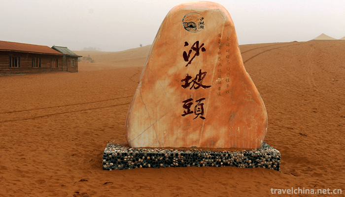
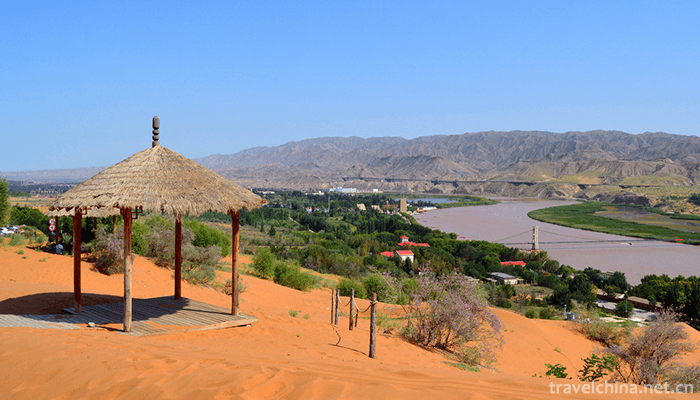
Shapotou is located in the southeastern edge of Tengger Desert in the west of Zhongwei City, Ningxia Hui Autonomous Region. From the east to the south of Erdao Shagou Forest Protection House, from the west to Toudaodun, north to the Tengger Desert, south to the Yellow River, about 38 kilometers long and 5 kilometers wide, with an altitude of 1300-1500 meters, the total area of 4599.3 hectares, accounting for 3% of the total land area of Zhongwei City. It is one of the 20 key desertification control areas in China.
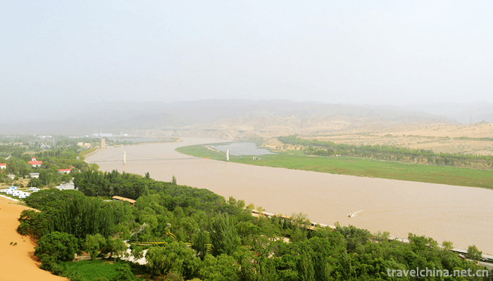
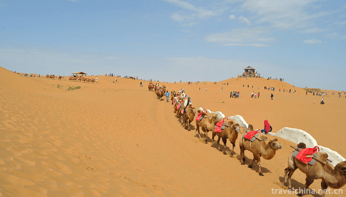
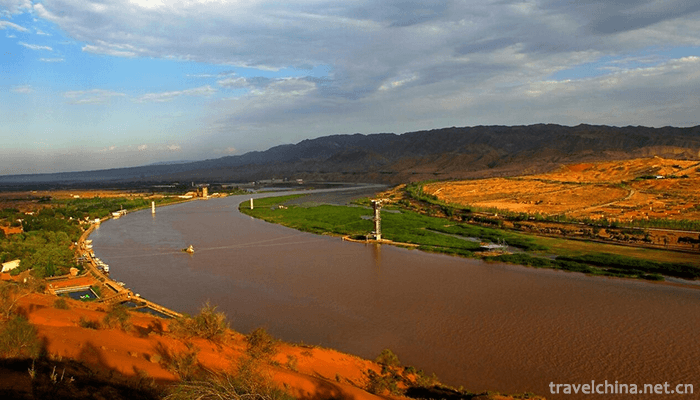
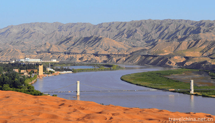
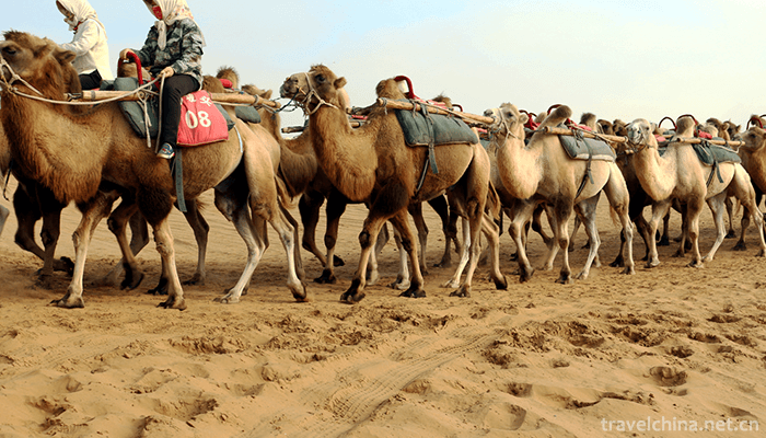
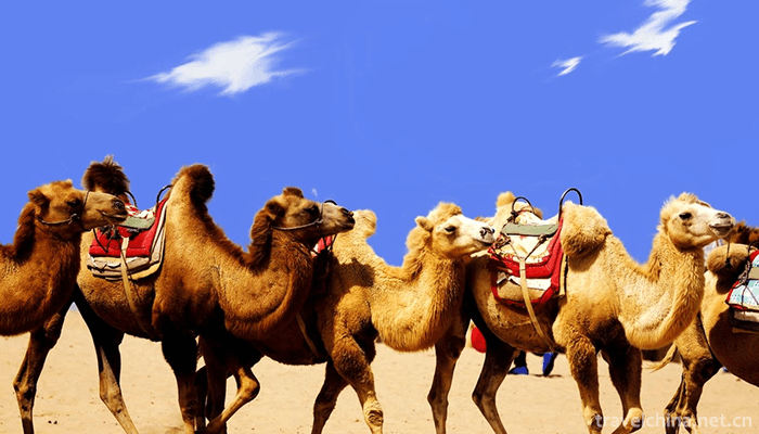
Shapotou is a place of desert, Yellow River, alpine and oasis. It has the magnificent scenery of Northwest China and the beautiful scenery of the south of the Yangtze River. There are China's largest natural sand sliding field, the "first rope of the Yellow River in the world" across the Yellow River, the ancient waterwheel represented by the Yellow River culture, the oldest transport vehicle on the Yellow River, sheepskin rafts, and mirages rarely seen in the desert. You can ride a camel across the Tengger Desert, you can ride an off-road vehicle to surf in the sand sea, and you can enjoy the spectacle of desert smoke and sunset in a long river within a short distance.
The main protected objects of Shapotou are natural desert landscape, natural desert vegetation, scientific research achievements of desert control, wildlife, ancient Great Wall of Ming Dynasty, bell ringing of Shapotou and its natural complex. In the 2008 Northwest China Tourism Marketing Conference and Tourism Equipment Exhibition, it was included in the "Magic Northwest 100 Sceneries" list. The 2008 China Yellow River Tourism Conference was named "50 Sceneries of the Yellow River in China". The Best Leisure Tourism Destination of China National Tourism in 2018.
geographical environment
position
Zhongwei City, which belongs to the nature reserve, is located at the western end of Ningxia Hui Autonomous Region and the junction of Ningxia, Gansu and Mongolia provinces. The territorial coordinates are 104 17'~105 37', 36 59'~37 43'. Located at the head of the front set of the Yellow River, Xiangshan in the south, Tengger Desert in the north, and alluvial plain in the middle of the Yellow River, the land area is 4599.3 km, which is one of the 20 key desert control areas in China.
Geology and geomorphology
The terrain of the reserve is high in the northwest and low in the southeast, inclining from the northwest to the southeast. Sand dunes are vertical and horizontal, with ups and downs. They cover the red sandstone, flood terrace and alluvial plain of the Second or Tertiary. The desert in the protected area is formed by the forward accumulation of the Tengger desert. The thickness of the sand layer is generally 20-30 m, and the thickest is up to 50 m. Most of them are ridge dunes, crescent dune chains, crescent dunes and lattice crescent dunes, which constitute typical aeolian landforms.
climate
The Nature Reserve belongs to the temperate continental climate, and belongs to the temperate arid climate zone in the National Natural regionalization. It has the characteristics of drought, less rain, strong evaporation, large temperature difference between cold and hot, abundant light, strong wind and sand, long winter, short summer heat, late spring and warm, early autumn and more meteorological disasters. The annual average solar radiation is 6.2 *10J/m, the sunshine hours are 2776.72 hours, and the annual average temperature is 9.6 C. The lowest temperature in January is -25.1 C. The highest temperature in July was 38.1 C, with an annual difference of 63.2 C, accumulated temperature of 3017 C (> 10 C), and frost-free period of 179 days (> 0 C). The annual average precipitation is 186.6 mm and the annual evaporation is 3000 mm. It is 16 times the annual average precipitation, 2.4 degree of dryness, more than 900 hours of wind-blown sand, 2.8 m/s average annual wind speed, sand days in March to June, the maximum wind power can reach grade 8. Strong winds are often accompanied by sandstorms, with an average of 5 to 19 days a year. The wind direction is mostly northwest. The main disastrous weather is drought, frost, gale, rainstorm, hail, hot and dry wind, cold damage and so on.
hydrology
The surface water in the reserve mainly includes the transit water of the Yellow River, the meteorological runoff and the spring lakes. The runoff of the Yellow River varies greatly during the flood season and the dry season. The natural ratio of water surface decreases to about 1/1300, the flow velocity in the flood season is 2.2-4.0m/s, the normal season is 1.7-3.0m/s, and the dry season is 0.77-2.0m/s. The average water depth is 1.8-8.7 m in flood period, 1.7-5.2 m in normal period and 1.6-3.7 m in dry period. The average flow rate is 1038 m/s. Controlled by the base structure, some closed inland lake basins were formed. Inland lakes, such as alkali lake, small lake, Gaodun lake, Machang lake and barren grass lake, have a total area of 721 hectares. They are habitats of various vertebrate fauna in the region.
soil
The soil types in Shapotou Nature Reserve are relatively complex, with six soil types distributed. The total area of soil is 13262.6 hectares, mainly sandy soil. In addition, there are lime-calcareous soil, tidal soil, newly accumulated soil, irrigated and silted soil and saline soil. The area of aeolian sandy soil is 10 610 hectares, accounting for about 80% of the total soil area of the reserve; the area of lime-calcareous soil is 1127 hectares, accounting for 8.5% of the total soil area of the reserve; the area of tidal soil is 1 326 hectares, accounting for 10% of the total soil area of the reserve; and the total area of newly accumulated soil, irrigation-silt soil and saline soil is only 199.6 hectares, accounting for 1.5%
-
2.century eggspreserved egg100years egg
Preserved egg, also known as preserved egg, egg, egg, egg, etc
Time 2018-10-12 -
3.Xiqiao Mountain Scenic Area
Xiqiao Mountain Scenic Spot is located in the southwest of Nanhai District, Foshan City, Guangdong Province, China. It has 72 peaks, forming numerous waterscapes, 232 springs and 28 waterfalls.
Time 2018-12-12 -
4.Zhangliangmiao Scenic Area
Zhangliangmiao, a holy place of Quanzhen sect, is located at the foot of Zibai Mountain on the southern slope of Qinling Mountains. It is 101 kilometers south of Hanzhong
Time 2019-03-16 -
5.Ziweidong Scenic Area
Seeing the pronoun of the first reaction of "purple cave" to "immortal" cultivation and residence, we often enchase that fairyland dream on this name.
Time 2019-03-22 -
6.Fried Wudong with XO sauce
Ingredients: 2 packs of instant Wudong, 4 or 2 pieces of pork shreds (about 160g), 1/2 cups of onion shredded, celery shredded and carrot shredded, 1 egg, 4 tablespoons of XO sauce, 1 tablespoon of ra
Time 2019-03-23 -
7.Carrying a number
Handling trumpets is one of the trumpets of traditional folk songs. It is popular in many fields, such as manual workers, such as loading and unloading, lifting, pushing and pulling goods.
Time 2019-04-03 -
8.Two tones of Han tune
Originally known as "Shan Er-huang", "Tu Er-huang" or "Shan Er-huang", the second largest traditional opera in Shaanxi Province is one of the traditional local operas in
Time 2019-05-02 -
9.Napo Zhuang Folk Songs
Napo Zhuang, also known as "Heiyizhuang", is a unique ethnic group among the Zhuang people. It calls itself "Min", "Zhong", "Ouch". Now there are about 518,000
Time 2019-06-06 -
10.Chengdu Sport University
Chengdu Institute of Physical Education is one of the six institutes directly under the former State General Administration of Sports. It is now a co-established Institute in Sichuan Province with the
Time 2019-08-31 -
11.Sichuan Minzu College
Sichuan College for Nationalities is a full-time general undergraduate college in Sichuan Province. It is also the only national undergraduate college in Kangba Tibetan District. It is located in Guza
Time 2019-08-31 -
12.Tips for Chengdu TourismTime 2020-11-28