Taining World Geological Park Fujian Province
Taining World Geological Park, Fujian Province
Fujian Taining World Geological Park, located in Taining County, Sanming City, northwest Fujian Province, covers an area of 492.5 square kilometers, of which Danxia landform covers an area of 252.7 square kilometers. The park is composed of four parks: Shiwang, Dajinhu, Baxianya, Jinfushan and Taining Ancient City Tourist Area. The park is a comprehensive geological park, with typical Danxia landform in youth as its main body, volcanic rocks, granite, tectonic landforms and other geological relics.
He has been awarded the National Key Scenic Spot, National 5A Tourist Area, National Forest Park, National Geopark, National Key Cultural Relics Protection Unit and so on.
On February 11, 2005, UNESCO approved Taining Geopark as the second batch of World Geoparks.
geographical environment
Location context
Fujian Taining World Geopark is located in Taining County, northwest Fujian Province, with an area of 492.5 square kilometers, of which Danxia landform area is 252.7 square kilometers. The geographic coordinates are 116 degrees 45'00 to 117 degrees 18'11 in the east longitude and 26 degrees 37'26 to 27 degrees 05'35 in the North latitude.
topographic features
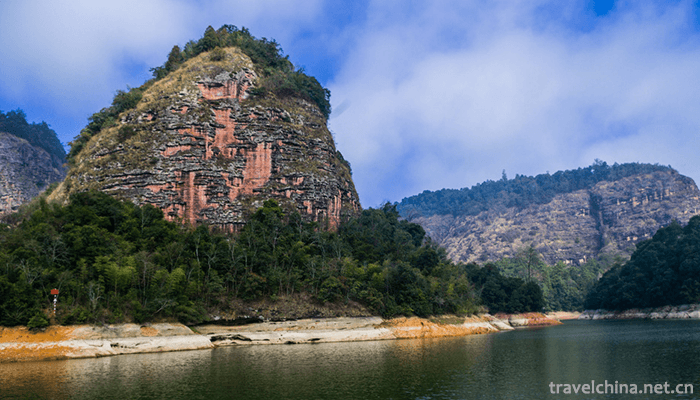
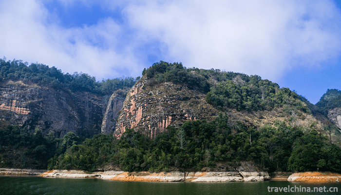
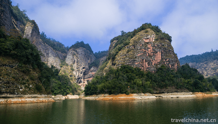
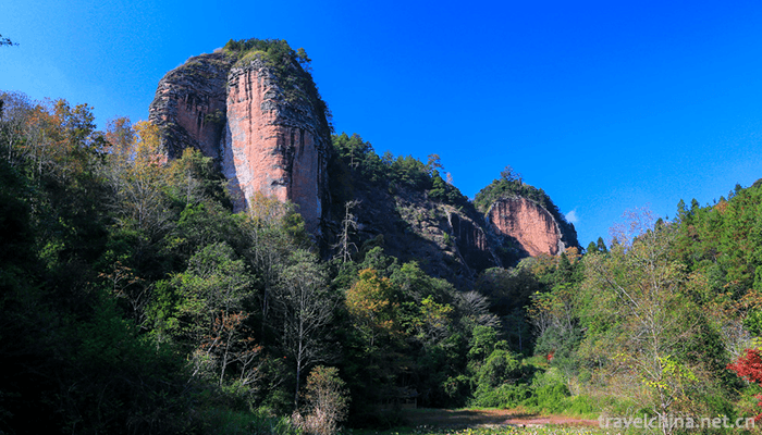
Taining Geopark, with Danxia landform as its main body and granite landform, volcanic landform and tectonic landform, constitutes a large comprehensive geological park. Among them, the Longwangyan and Dayading scenic spots of Shiwang Park, Dajinhu Park and Baxianya Park are Danxia landforms, Jinraoshan Park is granite landform, Baiya Mountain scenic area of Baxianya Park is volcanic landform.
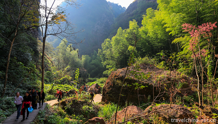
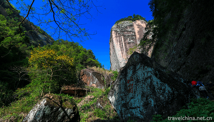
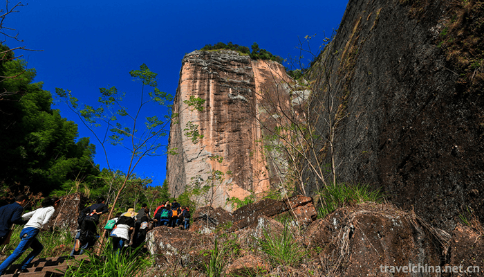
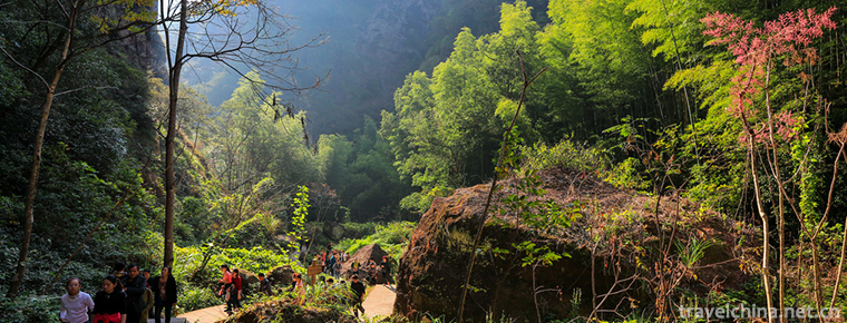
The most important feature of Danxia landform in youth is the extremely developed canyon. The complex fault system formed by multi-stage tectonic activities and the flowing water effect sculpted the landscape of the vertical and horizontal gullies of the Geopark. The Canyon group consisting of more than 80 line valleys (one line sky), more than 150 Lane valleys and more than 240 canyons is characterized by deep canyons, high Danya cliffs, numerous caves and natural ecology.
Climatic characteristics
Taining World Geopark is located on the southeast windward slope of the middle part of Wuyi Mountains. It belongs to the monsoon mountainous climate of the middle subtropical zone. Summer is not hot, winter is not cold. The four seasons are mild and humid, with abundant sunshine and rainfall. The annual average temperature is 17 C, the extreme maximum temperature is 38.9 C, the minimum temperature is - 10.6 C, and the frost-free period is about 300 days. There is abundant rainfall in the area, with an average annual rainfall of 1788 mm, relative temperature of 84%, and average sunshine hours of 1738.7 hours. It has abundant light and heat, long frost-free period, mild climate and good ecological environment.
Geological origin
The Taining World Geopark in Fujian Province has experienced a long and complicated geological evolution history. Since the Late Triassic, the park has been under the influence of the interaction between the Pacific plate and the Eurasian plate. From the late Jurassic to the early Cretaceous, there were large-scale volcanic eruptions and magmatic intrusions in the park. Since the Late Cretaceous, under the control of the Chong'an-Shicheng NE trending fault zone and the Taining-Longyan N-S trending fault zone, the park has formed a fault basin and deposited red strata dominated by glutenite. After the Late Cretaceous, the earth's crust was uplifted in an all-round way, and the re-active faults cut the rocks, resulting in differences in fissures and uplift, geological structure, water erosion, collapse and weathering, which made the peaks in the park rise flat and the Danya cliffs rise abruptly.
Resource situation
Water resources
The water system in Taining Geopark is well developed and belongs to the tributary of the upper Minjiang River. The main water system consists of Jinxi and its three tributaries, Suixi, Shanxi and Puxi, which converge in Taining. The combination of meandering middle-aged rivers and steep young rivers in the canyon is the basic characteristics of the rivers in the area. The park is characterized by deep canyon meandering.
Forest resources
There are more than 360 species of wild plants, rare tree species and 102 families in Taining World Geopark. Among them, there are more than ten species of trees under national protection, such as Metasequoia glyptostroboides, Taxus chinensis, Sophora japonica, Acer truncatum and Black Tea. Among them, dozens of red tea trees are the most rare, with nearly 25,000 mu of verdant forests.
Scenic spots
Mount Mao
Maoershan National Forest Park is located in Taining County, Sanming County, Fujian Province. It is near the ten-mile Pinghu scenic spot of Jinhu Lake. It is a brilliant pearl on the Dajinhu tourism line. The Park covers an area of 2,560 hectares. The main scenic spots are Jinmaoshan scenic spot, Heming Mountain scenic spot, Huangjiahu scenic spot and Pinghu scenic spot. Maoershan National Forest Park is rich in tourism resources, rich in forest vegetation and species. Fengyan Waterfall Spring and various human landscape scenery are of great variety and high visibility. First, green forests and lush vegetation. Park forest vegetation is lush, the forest coverage rate in the scenic area reaches 90%; second, the steep peak rock, strange tunnel gorge. The landform of Maoershan Forest Park is a typical Danxia landform, which is a very precious landform. The third is the beautiful Pinghu Lake and the beautiful waterfall pool. The park is surrounded by Pinghu Lake, with springs and waterfalls in mountains and streams in valleys. Fourth, it has a long history and magical legends. Fifth, it has a pleasant climate and beautiful environment. The park is steep and dense with high negative oxygen ion content, which is known as the "natural oxygen bar" of Jinhu Lake.
Zi Yuan rock
Located in Changxing Village, the northern suburb of Taining County, the scenic spot of Zhuangyuan Rock is 11.7 kilometers away from the downstream pier of Shangqing River and 16 square kilometers away from the urban area. It was named after Zou Yinglong (1173-1245) who studied here in the early years of the second year of Song Qingyuan (1196).
The tour of Zhuangyuan Rock Scenic Area is about 5 kilometers, which is divided into five tourist districts. All the tourist trails are paved with stone steps. There are more than 80 scenic spots such as Qianlong Gorge, Changguling, Feitianling, Wuhu Shangshan, Kongshan Liuxiang, Zhuangyuan Rock, Sunning Cliff and Jinxiu Valley.
Kowloon pond
Jiulongtan Scenic Area is located in Shangqing Township, 15 kilometers upstream of Jinhu Lake, adjacent to Shangqingxi and Zhuangyuan lithofacies. The development of scenic spots is positioned as "Wild Households, Ecological Paradise", with a total planning area of 167.2 hectares, which is divided into five functional areas: religious culture, Canyon exploration, water leisure, mountain homes and reception services.
The original name of Jiulongtan Scenic Area is Huanglonggang. It is named Jiulongtan because there are nine winding streams of water pouring into the pool. The main scenic spot is Danxia Lake, which is composed of Danxia landform. Its surface is about 5 kilometers long, the widest part is about 100 meters, the narrowest part is less than 1 meter, and the depth of the lake is up to 18 meters. The main scenic spots are Yinglong Gorge, Chimpanzee Wangtan, Qianmian Man, Yulong Cliff, Guifeiyan, Feilong Cave, Root Baoshi and more than 40 places. Among them, Yinglongxia scenic spot is about 1200M in length, which is the longest water front day.
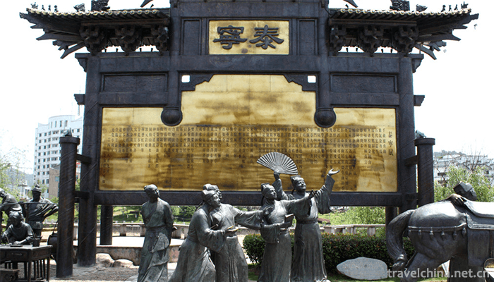
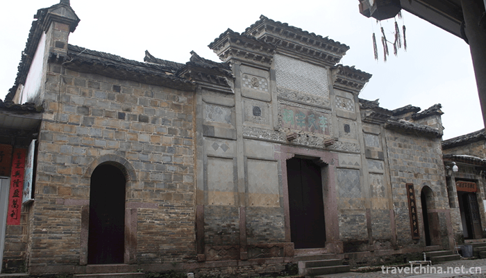
Ancient city of Taining
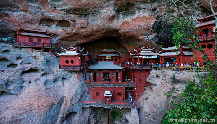
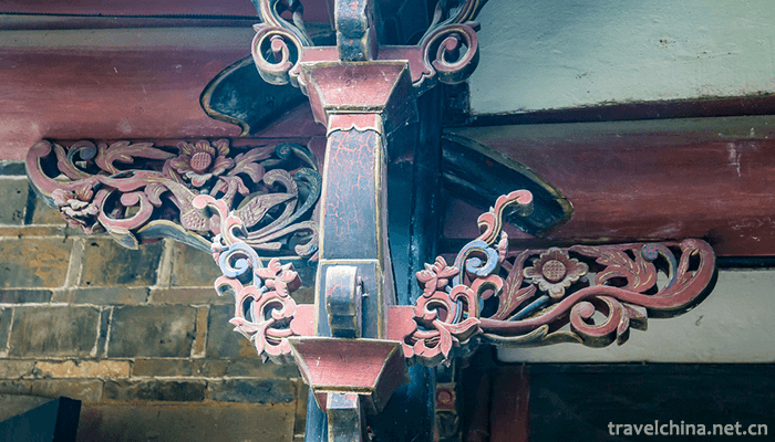
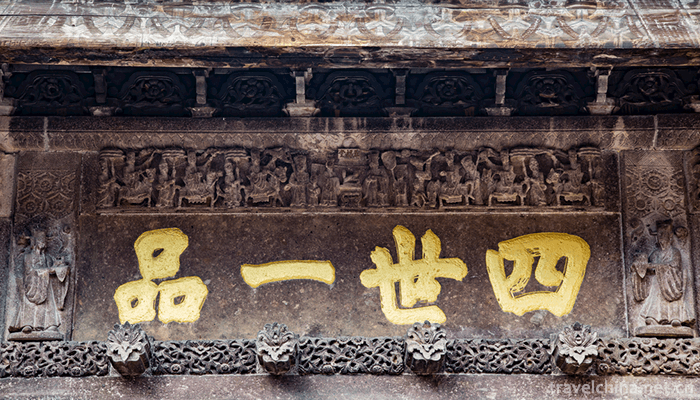
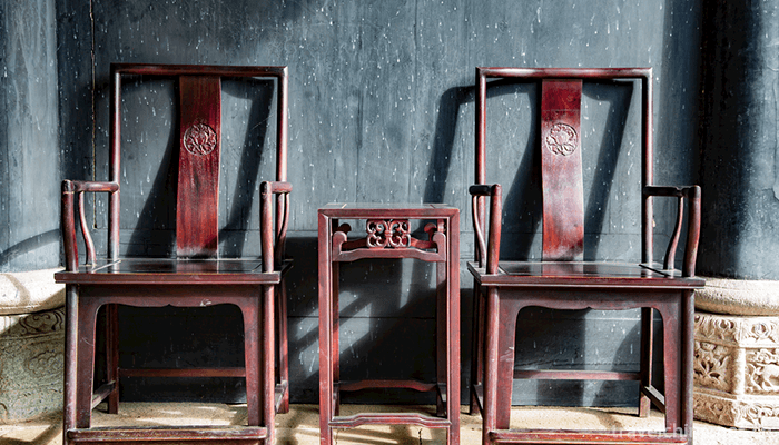
The ancient city of Taining is located at the Chengguan of Taining County at the southern foot of Wuyi Mountain, with a square area of 226.5 square kilometers. It has well-preserved authentic Ming Dynasty residential buildings, Shangshudi Architectural Complex, a national key cultural relic protection unit, and buildings of various periods from the early Ming to the late Qing Dynasty for more than 500 years. The ancient city of Taining has a long history. It has a history of 1340 years. It has the reputation of "Ancient Towns of Han and Tang Dynasties and Famous Cities of Song Dynasty". The ancient city of Taining was also the Central Soviet Area during the Second Revolutionary War in China. Shangshudi and Shidetang, the state's key cultural relics protection units, are located in the city. The old residences of Zhu De and Zhou Enlai and a large number of precious cultural relics are well preserved. The new Huizhou School's Qiaojiao Architecture, which is newly planned and constructed, is unique in imitating the ancient city of Song Dynasty.
Zhaixia Grand Canyon
Zhaixia Grand Canyon scenic spot is the key scenic spot of Taining World Geopark Dajinhu Park, which is the key scientific research scenic spot for Taining "Shenshi" experts. Jixi Village, located at the junction of Shancheng Town and Tianxiang Township, is 16 kilometers away from the county town. The scenic area covers an area of about 2 square kilometers. It is named after the scenic area, which looks like a giant dragon lying on its back.
The scenic spot is located in the geological fault zone from Shaowu, Fujian Province to Heyuan, Guangdong Province. It is a young Danxia landform canyon landscape formed and developed under the background of rift basin about 65 million years ago. The Canyon is deep and secluded, with dense vegetation in the canyon. The main geological landscapes are Danxia cave, Lane valley, line valley, red wall, stone wall, isolated peak, stone pillar, collapse accumulation, barrier lake, perforation, plate cross bedding, drifting gravel, stalactite and so on. The main scenic spots are Wentianyan, Sanxianyan, Qitianxia, Yitianjian, Fozuyan, Turtle Climbing Wall, Tiandome Rock, Cuizhu Lake, Yunyaling, Jinlong Line Valley Group, Turtle Temple Cascade, Line Waterfall, Cathay First Teng, Millennium Liushu King, Qiandongtengbi, etc.
Upper Qingxi
Shangqingxi Scenic Area is located in the northeast of Taining, upstream of Jinhu Lake, about 22 kilometers from the county to Shangqing. It got its name from Taoism, and "Shangqing" is one of the "three Qing Kingdoms" of Taoism, namely Taiqing, Shangqing and Yuqing. Later, it was widely used to refer to "fairyland".
Shangqingxi originated from Chuanli Village, Shangqing Township, Taining. It is more than 50 kilometers long. It passes through the hinterland of Shangqing and flows into Zhukouxi on Yaoping through Changxing Village, Shangcheng Town. Among them, the developed bamboo raft drifting reach is from Chongji to Changxing, which is 15 kilometers long and drifts for about two hours. The journey is divided into ten rafts, ninety-nine bends, eighty-eight beaches, seventy-seven bends, sixty-six peaks, fifty-five rocks, forty-four sceneries and thirty-three miles. The main attractions are "Carp Leaping Dragon Gate", "Golden Bell Changming", "Five Old Watchers", "Sunshine Triple" and "Peacock Kaiping, Qiying Cliff, Luoxia Wall and mirage.
Jinhu Scenic Area
Jinhu is a national key scenic spot, with water as the main body and Danxia landform as its characteristics. It is a rare scenic spot in China that combines Danxia landform with vast lake water. In 1980, the state built a 100,000 kW Chitan Hydropower Station on Luan Tan in the upper reaches of Jinxi. Due to the construction of the dam, an artificial lake with a long north-south and narrow East-West was formed in Taining County, which was named Jinhu because of Jinxi. The surface of Jinhu Lake is circular, like a crescent moon. The area of the scenic spot is 136 square kilometers, of which the water area is 38 square kilometers and the water storage is more than 700 million cubic meters. From Taining County to the dam of the power station, it is 62 kilometers long, so it is called "Baili Jinhu".
The water of Jinhu Lake is dark and blue, and the Island Lake is connected. Danya Cliff Waterfall, Ancient Temple, Fishing Boat Farm House and Ancient Mushan Flowers can be seen everywhere. There are more than 180 scenic spots and historic sites in the scenic area, such as Red Cliff, Water Line Sky, Maoer Mountain, Baishui Tiao Waterfall, Shili Pinghu Lake, Liquo Spring Rock, Hutou Rock, Manluyan and Manlu Temple, Yuanyang Lake, Lovers Peak, Valley Maze, Xiongzhu Peak, Suspension Bridge, Shangshu Tomb, etc.
Dan cliff, Chibi
Red Cliff Danya, commonly known as the Great Red Cliff. Red stone cliff is about 500 meters wide and 100 meters high. Its walls are barren of grass, reflecting red water through the lake, so it is called "Red Cliff".
A Sky on the Water
One of the representative scenic spots in Jinhu scenic spot is the sky above the water. Rock dangerous cliff, clasp two peaks, the lake water soaked over the hillside, forming a long dark green lane. On the left side of Shibi, the five big characters "A Line of Sky on Water" were inscribed by Liu Yi, former director of the State Tourism Administration. The waterway is only 2 meters wide and more than 300 meters long. The cliff is about 100 meters high.
Valley Valley maze
Valley labyrinth is commonly known as "the second line of the sky", formerly known as the 24 streams, refers to the meandering of 24 bends. The waterway is about 2 kilometers long, with cliffs on both sides. Ships turn left and right in the quiet canyon, giving people the feeling of turning around the peak circuit and confusing, so it is elegantly called the canyon maze.
Ten li Pinghu
The most open surface of Jinhu Lake is Ten Miles Pinghu. It is 8 kilometers long in North and south, 3 kilometers wide in East and west, and more than 60 meters deep in water. It is surrounded by mountains and islands. The two streams of Suixi in Jianning and Shanxi in Taining were originally there.
Here they meet to form a golden lake. On the right side of Shili Pinghu Lake, there is a huge stone on the top of the mountain, which resembles Hutou Rock. Under the mountain, there is a town named Meikou, so this mountain is also called Meiyan. There is a military fortress named Hutouzhai built in Song Dynasty.
Male pillar peak
Xiongzhu Peak is located on the left side of Shili Pinghu Lake. It is an isolated and tall rock, similar to genitals. The Chinese nation has had the custom of reproductive worship since ancient times, and this ancient culture is also spreading in Jinhu area. Hence the name Xiongzhufeng.
Suspension Bridge
Suspension bridge, 6 meters wide deck, 284 meters long, can pass through 10 tons of cars, the bridge head stele inscribed with "Jinhu Suspension Bridge" five characters.
Development and construction
In January 1994, Taining was approved as a national key scenic spot.
In 2001, Taining was awarded National AAAA Tourist Area and National Geopark.
On February 11, 2005, UNESCO approved Taining Geopark as the second batch of World Geoparks.
On January 30, 2009, Taining, Fujian Province, formally became one of the nominated sites for China's "World Natural Heritage" because of its unique Danxia geological heritage application.
Tourism information
Traffic Information
aviation
From Beijing, Shanghai, Hangzhou, Guangzhou, Hong Kong and other places to Fuzhou, Xiamen, Wuyishan, and then by car to Taining.
Train
From Beijing, Shanghai, Hangzhou, Guangzhou, Nanjing, Hefei, Nanchang, Fuzhou, Xiamen and other places directly to Shaowu, Shunchang, Nanping, Sanming, and then by car to Taining.
automobile
Taining is 76 kilometers to Shaowu, 146 kilometers to Wuyishan, 62 kilometers to Jiangle Yuhua Cave, 184 kilometers to Nanping, 176 kilometers to Sanming and 85 kilometers to Lichuan, Jiangxi. There are also passenger flights from Taining to Fuzhou, Putian, Shishi, Xiamen, Dongguan and Guangzhou.
Ticket Price Information
Name of scenic spot, fare
Jinhu 165 per person (including ship ticket and tour guide fee)
Shangqingxi 95 yuan per person (including drifting fee and tour guide fee)
Zhaixia Grand Canyon 55 yuan per person
Taining Ancient City 25 yuan per person
Kowloon Pool 55 yuan per person (including drifting fee, tour guide fee)
Zhuangyuan rock 40 yuan per person
Maoershan 40 yuan per person
Diboyuan 6 yuan per person (including tour guide fee, additional 30 yuan per person if you choose 4D cinema)
Hongshigou, free of charge
Li Jiayan Free
-
1.Tianjin Panshan Scenic Area
Tianjin Panshan Scenic Area, located 15 kilometers northwest of Jixian County, Tianjin City, covers an area of 106 square kilometers
Time 2018-11-24 -
2.The peak of unique beauty Duxiufeng
Duxiufeng is located in Jingjiang King's City in the center of Guilin City, Guangxi. It is an inseparable part of the King's City Scenic Area. Gufeng protruding, steep, magnificent, known as "a p
Time 2018-12-12 -
3.Abakh Hoja Tomb
Xiangfei Tomb is located in Haohan Village, 5 km east suburb of Kashgar City. It is a key cultural relic protection unit in the autonomous region. This is a typical Islamic complex of ancient building
Time 2019-02-25 -
4.Loba Costume
Clothing custom is an important manifestation of human material and spiritual cultural life, with a long history. The Loba people live in dozens of rivers and valleys in the vast Loba area, which are
Time 2019-05-15 -
5.Miao Lusheng Production Techniques
Miao Lusheng production process is complex, generally using scraping, cutting, through, hammering, clamping, drilling and other related tools, through the selection of materials, baking materials, mak
Time 2019-06-05 -
6.Min Opera Fujian Opera
Fujian Opera is the only existing opera that sings and reads Bai in Fuzhou dialect. It is prevalent in central Fujian, Eastern Fujian and Northern Fujian, and spread to Taiwan and Southeast Asia. It i
Time 2019-06-05 -
7.Brewing Techniques of Fen Liquor in Xinghua Village
The brewing process of Fen liquor in Xinghua Village is complicated. Fen liquor in Xinghua Village is finally brewed through six main processes: grinding, moistening, steaming, fermentation, distillat
Time 2019-07-08 -
8.Yangxin Tea Picking Opera
In May 2011, Gao'an City, Jiangxi Province, Linchuan District, Fuzhou City, Shaoguan City, Guangdong Province declared that tea-picking operas (Gao'an tea-picking opera, Fuzhou tea-picking opera, nort
Time 2019-07-10 -
9.Cao Zhi
Cao Zhi (192 - 232 December 27th), Zi Jian, Pei Guo Qiao County (now) Anhui province Bozhou City, born in East Wuyang (now Shenxian, Shandong, Juancheng). Cao Cao He was born with third sons from Quee
Time 2019-09-07 -
10.Lingshan Temple
Lingshan temple is located in Mianning County, Liangshan Prefecture, Sichuan Province. It is 8 km away from Mianning County. It is the most famous temple in Liangshan Prefecture. It belongs to Mianning County as well as Xichang Satellite Launch Center.
Time 2020-10-16 -
11.Chuanxindian earthquake site
Compared with Beichuan earthquake site, Yingxiu earthquake site and Hanwang town earthquake site, chuanxindian earthquake site in Shifang has unique advantages. It can fully reflect the great spirit of earthquake relief and has great protection and construction value.
Time 2020-11-05 -
12.Yibin secondary industry
In 2019, the total industrial added value of Yibin City is 99.082 billion yuan, an increase of 9.5% over the previous year, and its contribution rate to economic growth is 45.5%. At the end of the year, there were 824 Industrial Enterprises above Designated Si
Time 2020-12-18