Shibing Karst
Shibing Karst
Karst is karst. It is the general name of the geological function of water in dissolving rock (carbonate rock, gypsum, rock salt, etc.) mainly by chemical dissolution, supplemented by mechanical action such as erosion, latent erosion and collapse of running water, and the phenomena caused by these actions. The landform caused by karstification is called karst landform (karst landform).
Karst was originally the place name of the limestone plateau on the Istral Peninsula in Northwest Yugoslavia, meaning where the rocks were bare. There are typical karst landforms. The word "karst" is the representative of karst landform. China is the earliest country in the world to record and study karst landforms. It was recorded as early as the Jin Dynasty, especially in Xu Xiake's Travel Notes written by Xu Hongzu (1586-1641) of the Ming Dynasty.
Geographically distributed karst landforms are distributed in soluble rock areas all over the world. There are three types of soluble rocks: (1) carbonate rocks (limestone, dolomite, marl, etc.). (2) Sulfate rocks (gypsum, anhydrite and mirabilite). (3) halite rocks (potassium, sodium, magnesium salt rocks, etc.). The total area is 51 x 106 square kilometers, accounting for 10% of the total area of the earth. Karst landforms develop from tropical to cold zones, from continents to islands. The more famous regions are China's Guangxi, Yunnan and Guizhou provinces (regions), northern Vietnam, the Dinak Alps of Yugoslavia, the Alps bordering Italy and Austria, the Central Plateau of France, the Ural Mountains of Russia, southern Australia, Kentucky and Indiana of the United States, Cuba and Jamaica. Karst landforms in China are widely distributed and large in area. It mainly distributes in the areas where carbonate rocks are exposed, covering an area of 91-1.3 million square kilometers. Among them, Guangxi, Guizhou and the eastern part of Yunnan account for the largest area, which is one of the largest karst areas in the world. Tibet and some northern areas are also distributed.
Landform types
brief introduction
Karst can be divided into many different types. According to the outcropping conditions, it can be divided into bare karst, covered karst and buried karst. According to the climatic zone, it can be divided into tropical karst, subtropical karst, temperate karst, cold karst and arid karst. According to lithology, it can be divided into limestone karst, dolomite karst, gypsum karst and salt karst. In addition, there are also different divisions according to altitude, development degree, hydrological characteristics, formation period and so on. The phenomena similar to karst in morphology are produced by other different genesis. They are collectively called pseudokarst, including clastic karst, loess and clay karst, thermal melt karst and lava karst in volcanic rock area. They are not made up of soluble rocks and are essentially different from karst.
Surface karst morphology
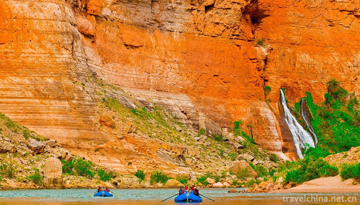
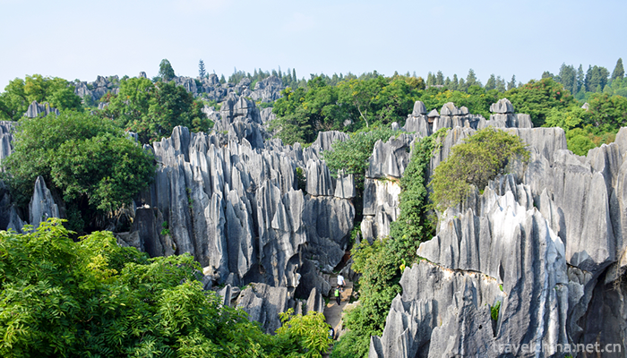
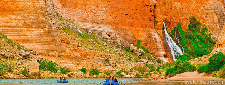
Solution ditches and stone bud surface water flow along the rock surface. Many grooves formed by erosion are called solution ditches. The prominent part between dissolving ditches is called stone bud. Stone Forest: This is a kind of tall stone bud, up to 20-30 meters, densely covered, so called Stone Forest. Limestone is formed under tropical rainy conditions because of its high purity, large thickness and level of layers.
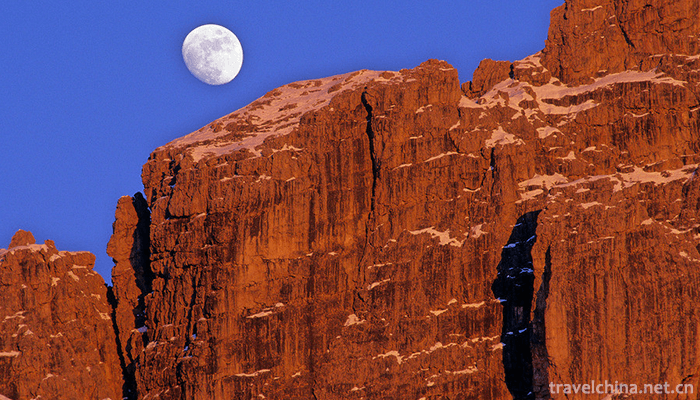
Peak clusters, peak forests and solitary peak clusters and peak forests are peak aggregates formed by strong dissolution of limestone. Among them, the peak cluster is the stone peak connected by the base, and the peak forest is formed by the further dissolution and evolution of the peak cluster to the depth. Gufeng is an isolated limestone peak in Karst area, which is mostly distributed in Karst basins.
Solution bucket and dissolution depression are circular or elliptical depressions on the surface of karst area. Solution depression is a closed depression surrounded by low mountains, hills and peak forests. If the channel at the bottom of the dissolution bucket and the dissolution depression is blocked, water can accumulate into ponds and large karst lakes can be formed.
Waterfall caves, dry valleys and blind valleys are the channels through which surface water flows to underground or underground karst caves in Karst areas. They are the continuous dissolution of fissures by vertical flow of karst water and are formed with collapse. In a falling hole in a river course, the water meeting part is often brought into the ground and the river is cut off to form a dry valley or blind valley.
Underground karst morphology
Cave: Also known as cave, it is the underground channel formed by the dissolution and erosion of groundwater along the layers, joints or faults of soluble rocks. The karst forms in karst caves mainly include stalactites, stalagmites, pillars, mantles, limestone and spring blooms. Longgong Palace in Anshun and Zhijin Cave in Zhijin County are the masterpieces of underground karst landforms.
Causes of formation
Modern karst in China developed on the basis of the quasi-plain after the Yanshanian movement. In the Old Tertiary, the climate in South China was tropical and the peak forests began to develop, while in North China it was subtropical. Up to now, there are still gentle hills and depressions in some watershed areas in the middle Shanxi and southern Taihang Mountains. But at that time, the north and south of the Yangtze River were desert areas, where karst development was very weak. During Neogene, the formation of monsoon climate in China laid a foundation for the present karst zonality. South China maintained a humid and hot climate, central China became humid, and karst development turned strongly. Especially since the Quaternary, the crust has risen rapidly, and the karst landforms have developed rapidly with complex types. With the alternation of glacial and interglacial periods, the climate zone changes frequently, but in the alternation, the climate has the characteristics of gradual southward migration. The northern boundary of tropical peak forests in South China is Dananling and Miaoling, and in Daoxian County, Hunan Province, it is 25 40'. It is about 26 degrees north latitude in Guizhou.
This boundary is about 3 to 4 latitudes north of the present tropical boundary. It can be seen that the northern boundary of the peak forest is not formed under modern climate conditions. Although the temperature and rainfall in eastern China are gradually changing northward, the difference of karst zonality is very obvious. This is because, influenced by the climate during the interglacial and interglacial periods, the temperature and rainfall in China are higher during the interglacial period, which is conducive to the development of karst. The development of karst was strongly inhibited by the cold and little rain during the glacial period. But the more tropics it goes, the less it will affect. In the tropical peak forest region, the conditions for the intermittent development of the peak forest are maintained, while the influence from central China to northeast is increasing. The intensity of karst action decreases rapidly northward, which makes the type change obviously. The vast northwest area has been in dry climate since the Tertiary, and is an area where karst is almost undeveloped.
China
China's karst landforms are widely distributed and of many types, which are rare in the world, mainly concentrated in the Yunnan-Guizhou Plateau and southwestern Sichuan. In China, carbonate rocks (such as limestone, dolomite, gypsum and rock salt) are widely distributed as the material basis of karst geomorphology development. According to incomplete statistics, the total area is 2 million square kilometers, of which bare carbonate rocks cover about 1.3 million square kilometers, accounting for about 1/7 of the total area of the country; Buried Carbonate Rocks cover about 700,000 square kilometers. Carbonate rocks are distributed in all provinces and regions of China, but most widely in Guangxi, Guizhou and Eastern Yunnan. Carbonate rocks are widely distributed in Western Hunan, western Hubei, Eastern Sichuan, Shanxi and Shandong provinces.
On June 23, 2014, the second phase of karst in southern China, consisting of Guilin karst (Guangxi), Shibing karst (Guizhou), Jinfoshan karst (Chongqing) and Huanjiang karst (Guangxi), was approved to be included in the World Heritage List at the 38th World Heritage Conference.
Zonal characteristics
The karst landforms in eastern China are zonal in latitude, and from south to north are tropical karst, subtropical karst and temperate karst. Due to water limitation or topographic influence, western China belongs to arid karst (northwest region) and frozen plateau karst (Qinghai-Tibet plateau).
tropic
It is distributed in Guangxi, western Guangdong, Eastern Yunnan and southern Guizhou. There are many underground caves, mainly dissolved arch caves. The subterranean river has many tributaries and a large basin area, so it is called groundwater system. The average basin area is 160 square kilometers, and the largest subterranean river basin area is 1000 square kilometers. There are many depressions on the surface. The average area of peak cluster is 2.5 per square kilometer. The distance between depressions is 100-300 meters. The normal topography is divided and fragmented, showing a peak-forest-depression landform. The slope of the peak forest is very steep, usually more than 45 degrees. Peak forest can also be divided into solitary peak, sparse peak and peak cluster. Strange peak cave is a typical feature of tropical karst.
Coral reefs in tropical oceans of China are the youngest carbonate rocks, mostly formed in the Late Pleistocene and Holocene. Only a few meters to more than 10 meters above sea level, there are large caves and natural bridges, coastal erosion cliffs, gullies and stone buds, which constitute the multi-solution pore landscape of coral reefs on reef islands.
Subtropics
It is distributed south of the Huaihe River in Qinling Mountains. Underground rivers are more and shorter than tropical rivers, with an average basin area of less than 60 square kilometers. There are fewer depressions, only about one per square kilometer, and they decrease from south to north. On the contrary, the proportion of dry valleys increases rapidly. Normal topography is not very typical, mainly steamed bread hills, its slope is generally about 25 degrees, the number of caves is much less than that in the tropics, with dissolution fissure caves in the majority, dissolution Arch Caves in the southern subtropical karst more.
Temperate karst is represented by karstified mountain dry valley
Although underground caves are well developed, they are generally fractured caves with small scale. Karst springs are more prominent, generally have larger catchment area and larger flow, such as Potu Spring and Niangziguan Spring. There are few mid-depressions and many dry valleys in this area. Normal topography is similar to that of ordinary mountain areas, but there are some remnants of paleo-subtropical gentle hills-depressions and gentle hills-dry valleys at the top of the mountain. Strong downcutting rivers form canyons, and some areas, such as the two sides of the Juma River, have similar peak forest landforms.
arid area
Only a few limestone fissures have slight corrosion marks, some fissures are filled with calcite, and underground karst caves are very few, which can not constitute the factors of leakage and foundation instability.
Cold plateau
The Qinghai-Tibet Plateau karst is under the action of glacial margin, with strong freeze-thaw weathering. The karst landform is quite distinctive. There are commonly freeze-thaw mounds, stone walls and so on. The lower part of the karst is covered with debris slopes formed by glacial margin. There are very shallow caves on the hillside, and some perforations can be seen. Occasionally depressions.
Development and utilization
Abnormal water shortage and flooding on the surface of karst area have a great impact on agricultural production. However, groundwater is abundant and runoff coefficient is 50-80% in tropical karst area. The subtropical karst area is 30-40%, and the temperate zone is 10-20%. In some limestone districts of North China, groundwater flows out in the form of springs in front of mountains, such as the springs of Yuquan Mountain in Beijing, Baiquan in Huixian County in Henan, Jinci Spring in Taiyuan, Shanxi, and Baotu Spring in Jinan. Reasonable development and utilization of karst springs is of great significance to the development of industry and agriculture. In the south, many underground rivers, such as diverting karst springs to block underground rivers, drilling and water extraction, can solve the problem of industrial and agricultural water use. The vertical section of the underground river is ladder-like, which has abundant hydroelectric resources and can be used to build dams to generate electricity. For example, the Liulangdong Hydropower Station in Qiubei, Yunnan Province, is the first hydropower station in China to utilize underground rivers. Hunan and Guizhou have also used this advantage to build more than 400 kilowatt underground water power stations. Underground caves in karst areas often cause reservoir leakage, which constitutes an unstable factor for dam body, transportation lines and factories and mines. Research and exploration of the distribution of underground caves and timely measures are the key to the success of construction in Karst areas. There are abundant deposits in Karst area, such as limestone, dolomite, marble, gypsum and rock salt. There are bauxite deposits on Karst denudation surface and depression, lead, zinc, sulfide and mercury placer deposits in ancient karst caves and fissures, and underground karst caves are also good places for oil and gas enrichment. Some oilfields in North China are located in Karst area. Some caves can be used as underground factory sites and underground warehouses.
Scenic spot
The multiple cycles and zonality of karst development in China have resulted in various karst landscapes and cave wonders, which are important tourism resources in China. Guilin Landscape (see Guilin City), Yunnan Shilin, Sichuan Jiuzhaigou (see Jiuzhaigou Natural Scenic Area), Guizhou Huangguoshu (see Huangguoshu Waterfall), Jinan Baotu Spring and the Juma River near Beijing have become world-famous tourist attractions.

-
1.White cut chicken
White cut chicken, also known as white cut chicken, is the most common dish in Guangdong cuisine. It is a kind of chicken dipping. Its characteristics are simple and easy to prepare, without batching
Time 2018-11-02 -
2.Donghekou Earthquake Relics Park
Donghekou Earthquake Site Park is the first earthquake site protection memorial site of Wenchuan Earthquake, located in Qingchuan County, Guangyuan City, Sichuan Province
Time 2018-12-20 -
3.Sun Yatsen Memorial Hall
Zhongshan Memorial Hall is located in Dongfeng Middle Road, Yuexiu District, Guangzhou City, Guangdong Province. It was built by the people of Guangzhou and overseas Chinese to commemorate Dr. Sun Yat
Time 2018-12-22 -
4.The Great Northern Wilderness Agricultural Expo
Beidahuang Agricultural Machinery Expo Park is a national AAAA-level tourist attraction located in Youyi County, 50 kilometers away from the city center, covering an area of 350,000 square meters.
Time 2018-12-26 -
5.Guangyou Temple Scenic Area
Guangyou Temple is located in Liaoyang City, Liaoning Province, with Baita in the West and moat in the east. It covers an area of 60,000 square meters. The central axis of the north and south is archw
Time 2019-01-13 -
6.Yuexiu Park Guangzhou
Yuexiu Park is the largest comprehensive park in Guangzhou. The main body of Yuexiu Park is Yuexiu Mountain. In the Western Han Dynasty, Zhao Tuo, the king of South Vietnam, was named after the "
Time 2019-01-13 -
7.Jindian Scenic Spot
Kunming Golden Palace Scenic Spot, also known as Tongwa Temple, is made of brass and shines in the sunshine, reflecting the golden brilliance of Cuigou Youlin
Time 2019-01-22 -
8.Five major tunes in southern Shandong
The five major tunes in southern Shandong, also known as Tan Ma Diao and Tan Ma Diao, are traditional folk song suites that are active in Tancheng County, Linyi City, Shandong Province, with Tan Town
Time 2019-05-15 -
9.Luonan Jing Blackboard
In 2011, Luonan Jingbanshu was approved by the State Council and listed in the third batch of national intangible cultural heritage list. As early as in the Daoguang period of the Qing Dynasty (around
Time 2019-05-15 -
10.Taoist Music of Xuanmiaoguan in Suzhou
The Taoist music of Suzhou, represented by the Taoist music of Xuanmiaoguan, belongs to the Zhengyi Taoist music, and is an integral art with the performing process of Zhai Yin Fa. It sings different
Time 2019-06-17 -
11.An Lushan
An Lushan (703 to 757 years). Yingzhou (today's Liaoning Chaoyang) Kang Name Rolling hill 。 His father may be kang Hu people Mother A Stead S is a the turks Witch. According to legend, his mother did
Time 2019-09-11 -
12.Meishan local culture
Meishan culture mainly includes Dongpo culture, longevity culture, Taoism culture, Buddhist culture, bamboo culture, water culture and so on. The past Meishan Dongpo Cultural Festival, Pengzu Shouxing Festival, Qingshen bamboo weaving art festival, Danling suona Festival, etc.
Time 2020-12-18