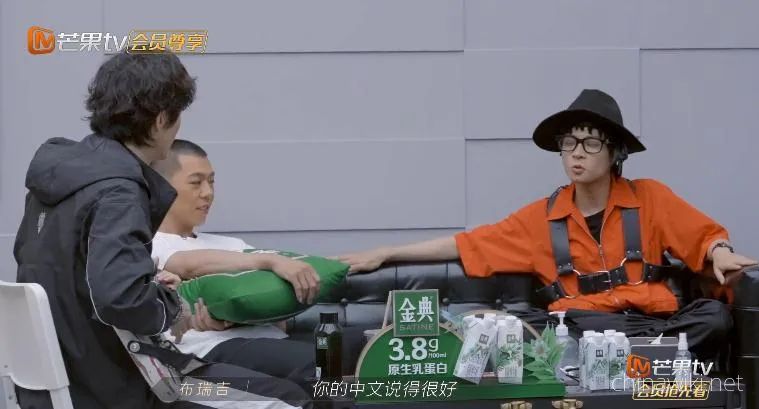
During their social time, Bridget and Gai praised Lee Seung Hyun, who spoke Chinese very well.
Lee Seung Hyun repeatedly waved his hand and said, I have been in China for 13 years. What qualifications do I have? If you stay in any country in the world for 13 years, you can certainly say anything
The truth seems to be this truth, but self modesty is also a bit.
After all, most of the time, Lee Seung Hyun's Mandarin can directly give Li Zhu the title of simultaneous translator. Even Yi Lijing, who is famous for his pickiness, has been amazed by him.
This praise is indeed not a day's work.
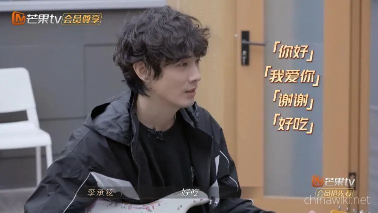
As a veteran of migrant workers in domestic entertainment, Lee Seung Hyun's Chinese level is really "said" step by step.
Li came to the mainland with a group around 2006. Like most foreign friends, he only said "Hello, thank you, delicious."
He first performed in the national drama "an angel will love you for me" that year. He has been consciously trying to learn Mandarin. Although he has just started, he is willing to be half a Chinese teacher for his teammates and urges the team to be friendly and practice Mandarin.
At that time, Korean stars were popular in entertainment. There were a lot of fans everywhere. When they returned to South Korea, they became unpopular. In contrast, Lee Seung Hyun gradually had the intention to leave South Korea for development in China. By the end of the year, he resolutely spent 6 million yuan to redeem himself and focus on filming in China.
When filming the fourth play (secret history of Yang Guifei) in 2009, he was already able to use Chinese for daily dialogue, but he could not read. When reading the script, the agent had to translate the Chinese into Korean, explain it again, and then memorize it by himself. He was afraid that the accent was too heavy, and the rival actors could not understand it. After reading the lines, he had to say, "I'm finished.".
Later, "I'm finished" was passed on from person to person in the crew. When everyone finished reading his lines to him, they all had to say, "I'm finished", like a code.
However, such hard work has also achieved some results.
In the list of few works in which Lee Seung Hyun's acting career was suddenly interrupted later, in the secret history of imperial concubine Yang, he played the role of Gao Xianzhi, which must be mentioned, and he and Shi Xiaoqun's Xie aman were a pair of good xipi.
During this period, Lee Seung Hyun's Chinese level was probably the stage when first graders "worked hard to learn pinyin".
At that time in 2010, Li's painting style was also very strange because he focused on weaving Bibs with Pinyin.
I don't know. I thought it was a junior who came to surf.
Reading his microblog, I have a fear of being dominated by pinyin.
Slowly, Chinese, English and Pinyin were mixed, and Lee Seung Hyun's microblog began to bring its own "voice" effect.
Although there are many wrong words, it is difficult to read, but it is also fun. When you read it once, you feel attached to foreigners.
、
I found that he had a "Daddy heart" for a long time and wanted to have a good girl Bora to play.
Comedy dish Xu Zhisheng tells us that not only looks but also accent are the killer mace of comedians. However, this truth has been verified many times by domestic entertainment migrant workers such as Lee Seung Hyun.
For example, Lee Seung Hyun has gone through the Pinyin stage and tried to accumulate his vocabulary. He passed the reading and writing level around 2011, but in the past few years, he still made a lot of jokes belonging to foreign friends in the variety show.
Sometimes it's really a little "promise".
Once, Qi Wei caught a loach and fell into a mud pit. Guo Jingfei laughed that the marks on her ass were like a volcano. He stood aside with you Rongyan and announced to the world: my wife's ass is huge!
In an interview with Yi Lijing, he said that at one stage, he really couldn't distinguish which words were swearing, so he learned and used them indiscriminately. Sure enough, after reading them out, he covered them all in the later stage.
He is a boasting party and always "boast" about his strange painting style.
Once, when she said that the singer's voice had lost its charm of "seducing" herself, Qi Wei rolled her eyes: that's attraction, not seduction!
Praise the contestants for their stable singing and a very "ancient voice". Qi Wei hurriedly popularized science: it's called retro!
She praised the female contestant for singing well, but accidentally pulled and stepped on it. "My wife also likes singing in KTV, but her voice doesn't feel so rusty as yours. There is another" defect "(I know you want to say characteristics)..."
Qi Wei: flaws?
Lee Seung Hyun was frightened and confused. In the tense atmosphere in which the audience was sweating for him, he desperately searched for the words buried deep in his brain: that kind, that kind, that kind... Granular feeling, granular feeling, granular feeling!
At a critical juncture, I got up in surprise and reported the answer. Finally, I escaped.
It's ok if you can't distinguish between positive and negative meanings. Everyone forgives him for the sake of foreigners.
One time, it was even funnier. Suddenly, he intimately called another guest Cai Qin "Xiaoqin". Cai Qin was stunned for 3 seconds and said happily that no one had called herself that for many years. We should have a good aftertaste.
Of course, the most absurd use of words occurred during the recording of my little couple. The director of the program group greeted Qi Wei and said that Qi Wei was his junior sister. Qi Wei stood up and bowed. Hello, senior brother.
While he was there, he also said, "good husband!"!
Yan Yikuan: shocked! Is that what husbands use?
Qi Wei smiled to death and said how do you recognize your husband casually?
Speaking, Lao Li's Chinese level is really "Schrodinger style".
When you think he is very good, he will make some jokes. For example, after the public stage performance of "brother cutting through thorns", he clearly wants to say that he is "lying to win", but what he says is "lying to send me away";
When you think he needs to be strengthened, he is accurate enough to shock you. Once Qi Wei asked him to show off his Sichuan dialect. He said it directly. He won't go to work tomorrow. It's cool. Bashi gets the board!
Tunnel to superclass.
Another contestant who is excellent at learning Chinese is Korean actress Lin Yuner. She came to China to make a film "Wu Shen Zhao Zilong". Later, she even went to take a Chinese intermediate examination certificate.
When she participated in the happy camp, she played games in Mandarin and was the best in the audience. She was the only one who didn't eat screws and get stuck.
You don't even need to bring a translator to record an interview. You can insert the network stem in the whole process, and you can update the stem with the dialect.
Many migrant workers in China have this kind of "contrast buff" that I want to practice Mandarin well and surprise everyone.
For example, Liu Xianhua, a Chinese Canadian, could read "Silk pulling sweet potato" as "Uncle Ba sweet potato" in the mushroom house. Once he challenged the idiom to say "a dog jumped over the wall". Finally, he came back and forth to a "flying dog house", which made Yang di laugh.
Another person who is not a foreigner but enjoys a similar buff is Wang Jiaer.
He is from Hong Kong. He grew up in a Cantonese environment. Speaking Mandarin often makes people laugh.
Gale has two big stems in her life.
First, idioms.
Once he Jiong boasted that he had made a lot of progress in Mandarin. He immediately showed a "look at him with new eyes", and everyone was happy. He came again with "a body of dog shit", and everyone stopped: is a body of dog shit also an idiom?
He changed, oh, is it a dog with ten bodies? Shit duck?
Finally, I found that what he wanted to say was "near death"!
I have to feel for gale that Chinese characters are really broad and profound. These four words are arranged and combined arbitrarily in his mouth, and they all have their own meaning.
In addition to idioms, Wang Jiaer also has an inescapable curse of "Erhua sound" - the challenge of adding "Erhua sound" after which word seems to be "Chinese Bermuda", which likes to test the Putonghua level of stars in Hong Kong and Taiwan.
Gale has been cue asked this question again and again recently.
Recording hi Fang Pai, Chen Feiyu, who took a taxi together, was enthusiastic about teaching him Beijing dialect. After teaching for a long time, they still couldn't figure out where to add "Er". Wang Jiaer, who felt that you can add Er anywhere, sighed that my tongue was too tired and had a rest.
In an interview, reporters have to embarrass him with this stem.
——Just ask the following option, which word is suitable for adding "Erhua sound" after it? Wang Jiaer chose a. the host told him it was c. he was shocked and felt that the host was playing with him.
Idioms and dialect slang are indeed the Achilles heel of many junior contestants in learning Chinese.
Therefore, compared with Lee Seung Hyun, who likes to boast about "beauty and wisdom", he is really powerful.
Although he is still in the exploratory stage in the face of many strange idioms, he can guess the general meaning by guessing.
Once he was reading a picture book with his daughter lucky. Lucky asked him what a lamb survived. He asked Hong Tianming for help. Hong Tianming said he was also very good, so he forcibly explained that the sheep was lucky and escaped. And luck means lucky.
The new interpretation of idioms is actually very posted, and even can turn to their own daughter. The language talent of flexibly connecting with the context is really Hong Kong.
Another time, Zhang Shaogang suddenly cue him on the stage and asked him to explain what is "everlasting" and "long flowing water".
He said in silence, I can't read, but the long stream of water should be playing with Qi Wei. I can play like water for a long time.
For a long time, that is, a long day and a long time on the ground. That is, time seems to stop. It describes two people's good feelings. If this idiom has six words, it can probably add "sea depth".
When learning idioms, I don't forget to implant my wife and daughter. This brain hole and association are shocking.
So at the beginning, I was lazy and didn't practice English. I just wanted my husband to learn Mandarin so that it would be convenient for Mr. Qi Wei, who won a quarrel, to really teach well!
0 Questions
Ask a Question
Your email address will not be published.