Luoping County
Luoping County is located on the slope of the transition from the eastern Yunnan Plateau to the western Guizhou Plateau. The terrain is high in the northwest and low in the southeast. The topography and geological structure is complex. The western and northern parts of Luoping County are relatively complete Eastern Yunnan Plateau. The central part of Luoping County is a lake basin of karst fault depression. The eastern and southern parts are eroded and cut by rivers, forming a landform of alternating low mountains and canyons. The highest elevation is 2468m, the main peak of Baila mountain, and the lowest elevation is 2468m The Sanjiangkou of Buge township is 722m, with a relative height difference of 1746m. Luoping County has been awarded the "national top 100 tourism county", "national advanced county in grain production", "the largest county in tobacco production", "national civilized county" and other city cards.
Luoping County
Luoping County is one of the counties under the jurisdiction of Qujing City, Yunnan Province. It is 75 kilometers wide from east to west and 99 kilometers long from north to south, covering an area of 3116 square kilometers
. Luoping County is 207km away from Kunming, the provincial capital, in the west, 120km away from Qujing City in the north, 71km away from Xingyi City in Guizhou Province in the East, and 156km away from Xilin County in Guangxi Zhuang Autonomous Region in the south.
Luoping County, with a population of 540000 in 2010, has jurisdiction over three streets, four towns and six townships. In 2013, the GDP of Luoping County was 13.5 billion yuan, ranking 22nd in Yunnan Province. Luoping County has been awarded the "national top 100 tourism county", "national advanced county in grain production", "the largest county in tobacco production", "national civilized county" and other city cards.
In 2018, the national health county (township) was reconfirmed.
On September 29, 2018, Luoping County was approved to withdraw from the poverty-stricken county by Yunnan provincial Party committee and government.
On January 25, 2019, it was selected as the national "safe agricultural machinery" Demonstration County in 2018.
Yunnan is one of the first batch of provincial tourism demonstration areas.
Historical evolution
In the Western Han Dynasty, the state of louwoguo / louwohou / Yelang (today's Luoping) was set up, which was under the jurisdiction of Jue county.
The Sui Dynasty was the territory of Nanning.
In the early Tang Dynasty, it was subordinate to the general government of Nanning Prefecture, and was a territory of Langzhou during the reign of Zhenguan. Tianbao years for Luoxiong department, belongs to the Nanzhao Shicheng County.
Song Dynasty was one of the thirty-seven tribes of wuman in dongcuan, which belonged to Shicheng County of Dali state.
Yuan to yuan 13 years (1276) home luoxiongzhou jurisdiction also Zuo County, Qujing road.
In 1587, it was renamed luopingzhou, belonging to the military and civilian government of Qujing. Along the Qing Dynasty.
Luoping County was called Luoping County in 1913, belonging to the middle of Yunnan Province. In 1929, Tao was abolished and Zeng Zhili Province was established.
In March 1950, the county people's government was established, which belongs to Yiliang special district and was incorporated into Qujing special district in 1954.
In October 1958, Luoping County was abolished and merged into Shizong County. In February 1959, Shizong County separated from Luxi, and Shizong and Luoping merged into Luoping County.
In 1961, Shizong County was separated out and the organizational system of Luoping County was restored.
administrative division
In 2013, Luoping County governs 3 streets, 4 towns and 6 townships: Luoxiong street, Lashan street, Jiulong street, Banqiao Town, fule Town, Majie Town, agang Town, LAOCHANG Township, Zhongshan Township, Dashuijing Township, Lubuge nationality township, jiuwuji nationality township and Changdi nationality township. There are 7 residents' committees, 147 villagers' committees, 1244 natural villages and 1771 villagers' groups.
geographical environment
position
Luoping County is subordinate to Qujing City, Yunnan Province. It is located between 103 ° 57 ′ - 104 ° 43 ′ E and 24 ° 31 ′ - 25 ° 25 ′ n. It is 75 km wide from east to west, 99 km long from north to south, covering an area of 3025 square kilometers, of which 78% is mountainous area; it borders Xingyi City of Guizhou Province along Huangni River in the East; it faces Xilin County of Guangxi Zhuang Autonomous Region across the river by Nanpan River and Qingshui River in the southeast; it borders Shizong in the southwest; and it borders Luliang, Qilin and Fuyuan counties (districts) from west to north. It is 207 km from Kunming in the west, 120 km from Qujing in the north, 86 km from Xingyi in Guizhou in the East and 156 km from Xilin County in Guangxi Zhuang Autonomous Region in the south.
Geology and geomorphology
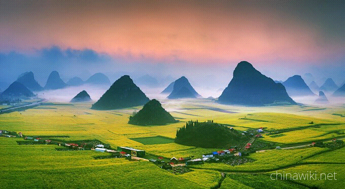
Luoping County is located on the slope of the transition from the eastern Yunnan Plateau to the western Guizhou Plateau. The terrain is high in the northwest and low in the southeast. The topography and geological structure is complex. The western and northern parts of Luoping County are relatively complete Eastern Yunnan Plateau. The central part of Luoping County is a lake basin of karst fault depression. The eastern and southern parts are eroded and cut by rivers, forming a landform of alternating low mountains and canyons. The highest elevation is 2468m, the main peak of Baila mountain, and the lowest elevation is 2468m The Sanjiangkou of Buge township is 722m, with a relative height difference of 1746m.
hydrology
The main rivers in Luoping County are Jiulong River, kuanze River, Huangni River and badahe River (Nanpan River). They flow through the middle, northeast, Southeast and southwest of Luoping County respectively, and gather in Sanjiangkou. They flow into the Pearl River through Guangxi and return to the South China Sea.
climate
In Luoping County, except badahe area in the South belongs to south subtropical climate, the rest belongs to plateau monsoon climate. In summer, it is affected by warm and humid air flow, with heavy rain and rainstorm; in winter, it is controlled by Kunming stationary front, with continuous rain. The annual average rainfall is 1743.9 mm, which is one of the rainy areas in the province. The annual average relative humidity is 85%, the annual average sunshine hours is 1685 hours, the annual average temperature is 15.1 ℃, and the annual average frost free period is about 280 days. Luoping has a mild climate with an average temperature of 15.2 ℃ and a frost free period of 280 days. It has high accumulated temperature and abundant rainfall with an annual rainfall of 1700mm.
natural resources
land resource
The total amount of land resources in Luoping County is 4.4287 million mu, of which forest land accounts for 28.5%, wasteland 36.5%, water area 0.7%, hard to use land 6.8%, garden land 0.2% and other land 77%. Cultivated land is mainly distributed in Bazi of Luoping, small mountain basins and mountainous areas with slopes of about 25 degrees. There are more than 80 small mountain basins with an area of 30-3000 Mu and 40 Bazi with an area of more than 1000 mu.
Hydropower resources
As of 2014, the proven hydropower reserves in Luoping County are 1.05 million kilowatts, and 929000 kilowatts have been developed and utilized, which is known as the "hometown of electric power"
. Since the 1960s, small hydropower stations have been widely built in the vast rural areas of Luoping County; since the 1970s, Jiulonghe hydropower station with an installed capacity of 4800 kW and Dazhai hydropower station with an installed capacity of 60000 kW have been successively built; in the 1980s, Lubuge Hydropower Station (with an installed capacity of 600000 kw), the first large-scale hydropower station built with foreign investment in China, and Lazhuang hydropower station, the largest county-level hydropower station in China, have been built The power station (with an installed capacity of 60000 kW) has 18 large, medium and small hydropower stations.
mineral resources
The survey data show that there are nine main mineral deposits in the county, including coal, lead and zinc, marble, pyrite, gypsum, copper, iron and gold. Lead and zinc is one of the main minerals in Luoping County, with proven industrial reserves of 3.582 million tons and average ore grade of 4.69%. It is mainly distributed in laojuntai, tuoniu, jizitang and weilutang of fule town. Now there are lead and zinc smelters. Its geological reserves are 6.7 billion tons of coal, 50 million tons of pyrite, 200000 tons of iron ore and 10 million cubic meters of marble.
Population nationality
At the end of 2011, the total population was 540000, including 148200 non-agricultural population, accounting for 27.04% of the total population. Yi, Zhuang, Miao, Hui, Yao, Buyi, Shui and other ethnic groups live in the territory. The population of ethnic minorities is 83000, accounting for 13.54% of the total population. The population density is 203 per square kilometer.
Economics
overview
In 2011, the gross domestic product of Luoping County was 9.3 billion yuan, an increase of 13% over 2010, and the total fiscal revenue was 880 million yuan, an increase of 21.5% over 2010. Among them, the local general budget revenue was 405 million yuan, an increase of 18.1% compared with 2010; the fixed assets investment was 4.564 billion yuan, an increase of 27.2% compared with 2010; the total foreign trade import and export was 54.2 million US dollars, an increase of 152.6% compared with 2010; the total retail sales of social consumer goods was 2.383 billion yuan, an increase of 20% compared with 2010.
primary industry
In 2011, Luoping County achieved a total agricultural output value of 4.8 billion yuan, an increase of 23% over 2010. The annual sales revenue of 25 leading agricultural enterprises in the county reached 1.5 billion yuan. The annual grain output was 285 million kg, an increase of 8.5% over 2010. The output of rape is 120 million kg and the output value is 600 million yuan, which is 107% higher than that of 2010. 760200 tons of tobacco were purchased, with an output value of 696 million yuan and a tax revenue of 153 million yuan, making it the largest county in tobacco production in China. We will build 500000 Mu rapeseed production base, 150000 Mu turmeric production base, 100000 Mu pollution-free vegetable production base, 50000 Mu aquaculture base and 10000 mu Chinese herbal medicine planting base. A subsidy of 9.78 million yuan was given to build 105 standardized pig breeding areas, 14 beef cattle and 14 mutton sheep breeding areas, and 1.163 million pigs were sold in the whole year, an increase of 7.1% over 2010. Luoping County completed 60000 mu of woody oil planting with high standards, and 200 agricultural cooperatives (associations).
the secondary industry
In 2011, Luoping County Industrial Park
Luoping County Historical evolution
During the Western Han Dynasty, the states of Louwo, Louwo Hou, and Yelang (now Luoping) were established, under the jurisdiction of Cuan Commandery.
Sui was a territory of Nanning Prefecture.
In the early Tang Dynasty, it was under the jurisdiction of the General Administration of Nanning Prefecture, and during the Zhenguan period, it was a territory of Langzhou. During the Tianbao period, it was under the jurisdiction of Luo Xiong and belonged to Shicheng County of Nanzhao.
During the Song Dynasty, it was one of the thirty-seven tribes of the Eastern Cuan Wuman, under the jurisdiction of Shicheng County in Dali State.
In the 13th year of the Yuan Dynasty (1276), Yizuo County was established under the jurisdiction of Luoxiong Prefecture, belonging to Qujing Road.
In the fifteenth year of the Ming Wanli reign (1587), it was renamed Luopingzhou and became part of the Qujing Military and Civilian Prefecture. Clear along with it.
In the second year of the Republic of China (1913), it was first called Luoping County and belonged to Dianzhong Road. In the 18th year of the Republic of China (1929), Dao was abolished and Zhili Province was established.
After the establishment of the People's Republic of China. In March 1950, the county people's government was established, belonging to the Yiliang Special Zone. In 1954, it was merged into the Qujing Special Zone.
In October 1958, Luoping County was abolished and merged into Shizong County. In February 1959, Shizong County was separated from Luxi, and Shizong and Luoping merged to form Luoping County.
In 1961, Shizong County was separated and the administrative system of Luoping County was restored.
Luoping County administrative division
As of 2023, Luoping County has jurisdiction over three streets: Luoxiong Street, Lashan Street, and Jiulong Street, four towns: Banqiao Town, Agang Town, Fule Town, and Majie Town, and six townships: Laochang Township, Zhongshan Township, Dashuijing Township, Lubuge Township, Jiuwuji Township, and Changdi Township, with a total of 154 villages (communities). The county government is located at No. 2 Mingzhu Road, Luoxiong Street.
Luoping County geographical environment
Luoping County Location Domain
Luoping County is located on the eastern edge of Yunnan Province, at the junction of Yunnan, Guangxi, and Guizhou provinces (regions). Located between longitude 103 ° 56 ′ 48 ″ E to 104 ° 42 ′ 36 ″ E and latitude 24 ° 32 ′ 40 ″ N to 25 ° 24 ′ 40 ″ N, it borders Xingyi, Guizhou along the Huangni River to the east, faces Xilin County, Guangxi Zhuang Autonomous Region across the Nanpan River and Qingshui River to the southeast, is adjacent to Shizong County to the southwest, and borders Luliang, Qilin, and Fuyuan counties (districts) to the west and north respectively. The maximum horizontal distance between east and west is 75 kilometers, the maximum vertical distance between north and south is 99 kilometers, and the total area is 3018 square kilometers.
Luoping County topographic features
Luoping County is located on the eastern edge of Yunnan Province, at the junction of Yunnan, Guangxi, and Guizhou provinces (regions). Located between longitude 103 ° 56 ′ 48 ″ E to 104 ° 42 ′ 36 ″ E and latitude 24 ° 32 ′ 40 ″ N to 25 ° 24 ′ 40 ″ N, it borders Xingyi, Guizhou along the Huangni River to the east, faces Xilin County, Guangxi Zhuang Autonomous Region across the Nanpan River and Qingshui River to the southeast, is adjacent to Shizong County to the southwest, and borders Luliang, Qilin, and Fuyuan counties (districts) to the west and north respectively. The maximum horizontal distance between east and west is 75 kilometers, the maximum vertical distance between north and south is 99 kilometers, and the total area is 3018 square kilometers.
Luoping County climate
Luoping County belongs to the subtropical plateau monsoon climate, located on a low latitude plateau. Influenced by the monsoon, the four seasons are unknown, with distinct dry and wet conditions. In addition, the rivers in the area are deeply cut and the altitude difference is large, so the three-dimensional climate and community climate are obvious. Except for the southern Lubuge Township, which belongs to the South Asian tropical climate, the rest are plateau monsoon climate. The climate in the territory is mild, with no intense heat in summer and no severe cold in winter. There is abundant rainfall. Influenced by the warm and humid air flow in the Bay of Bengal, there are many heavy rains and rainstorm in summer; In winter, under the control of the stationary front in Kunming, it is often cloudy and rainy, creating unique natural conditions for the high yield of rapeseed in Xiaochun. Rainfall is mainly concentrated from May to August, accounting for 87.8% of the total annual rainfall; Rainfall has the characteristics of high intensity, short duration, single point rainstorm concentration, etc. The annual average rainfall is 1743.9mm, which is one of the rainy areas in the province. The annual average temperature is 15.1 ℃, with July being the hottest month with an average monthly temperature of 21.2 ℃, and January being the coldest month with an average monthly temperature of 6.4 ℃. The average annual frost free period is about 280 days, the average annual hail is 2.1 days, rainstorm is 70.5 days, and fog is 38 days. The average annual humidity is 82%, the average annual sunshine hours is 1685.8 hours, and the sunshine rate is 38%. The dominant wind direction is southwesterly, with a maximum wind speed of 19.7 meters per hour.
Luoping County hydrology
The surface water system in Luoping County is relatively developed, all of which belong to Nanpan River and its primary and secondary tributaries in the Xijiang River system of the the Pearl River basin. The main rivers are Nanpan River, Huangni River, Zhuanchang River, Jiulong River, Xijiuxi River, Blocker River, Dagan River, Duoyi River, Niujie River, etc. The total drainage area is 2933 square kilometers, and the total water resources are 2.418 billion cubic meters (including 833 million cubic meters of groundwater). The river flows mostly from northeast to southwest, flows through the middle, northeast, southeast and southwest of the county, and converges at Sanjiangkou, and flows through Guangxi to the Pearl River.
Luoping County natural resources
Luoping County land resource
The total land resources in Luoping County are 4.4287 million mu, of which forest land accounts for 28.5%, grassland accounts for 36.5%, water area accounts for 0.7%, difficult to use land accounts for 6.8%, garden land accounts for 0.2%, and other land accounts for 77%. The cultivated land is mainly distributed in Luoping Basin, small mountain basins, and mountainous areas with a slope of about 25 degrees. There are more than 80 small mountain basins with an area of 30-3000 acres and 40 dams with an area of over 1000 acres.
Luoping County Water resources
Luoping County has built 18 large reservoirs, including Agung Reservoir, medium-sized reservoirs such as Longwangmiao Reservoir and Wanzi Reservoir, as well as other small reservoirs; Build 53 medium-sized irrigation canals in Bailashan, medium-sized irrigation areas in Wanzi and Angangcao Baihai, and other small-scale irrigation areas.
The main large and medium-sized reservoirs in Luoping County include Longwangmiao Reservoir, Wanzi Reservoir, and Lubuge Reservoir. Among them, Longwangmiao Reservoir is the centralized drinking water source of the county, and Wanzi Reservoir is the backup drinking water source. There are a total of 18 reservoirs in the county, including 2 medium-sized ones, 4 small (I) type ones, and 12 small (II) type ones. The total storage capacity is 33.0973 million cubic meters, and the Xingli storage capacity is 25.5902 million cubic meters. The compliance rate of surface water sources for urban centralized drinking water is 100%.
Luoping County mineral resources
The coal resources in Luoping County account for 31.5% of the county's total land area, with a prospective resource of 6.76 billion tons. The total proven coal reserves are 1.137 billion tons, and the pyrite reserves are 6.97 million tons; Lead ore reserves amount to 2.69 million tons; The reserve of zinc ore is 5.08 million tons.

Luoping County
-
1.Sculpture Time Cafe (Sanlian store)
Sculpture Time Cafe (Sanlian store) - Diao Ke Shi Guang Ka Fei Guan San Lian Dian
Time 2021-02-24 -
9.Heifengling scenic spot
Heifengling scenic spot - Hei Feng Ling Zhong Guo Di Jing Qu
Time 2021-02-28